Yangudi Rassa National Park

It’s not a surprise that Africa is a place of amazing parks, but
none combines such a variety of stunning landscapes and wildlife as
Afar’s Yangudi Rassa National Park. Not only you can catch incredible
close up view of the wildlife daily activities but you can also explore
the nearby world’s spectacular landscapes.

There are truly few places on Earth that blend culture and nature as
incredible as the one you see in Afar. Yangudi Rassa National Park lies
in the warm Afar region holding 4730 square kilometers of territory next
to the massive Mount Yangudi.  Sandy semi-desert and wooded bush and
grass cover the majority of the park’s area.  It’s home to several wild
animals and birds including the wild Ass, Beisa Oryx, Soemmering’s
gazelle, gerenuk and Grevy’s zebra, Phoenicopterus, Petronia
brachydactyla and Ardeotis arabs.

This national park was proposed to protect the
African Wild Ass. Recently, the Wild Ass went extinct in Yagundi Rassa.
However, there is a small population in the adjacent Mile-Serdo Wild Ass
Reserve (8,766 km²). The park headquarters are in the town of Gewane. A
large part of the park is composed of extensive grasslands and
thickets. With an average altitude of 500 masl, the climate of the park
is hot and dry for a larger part of the year. It has an estimated area
of 5,400 sq km and is covered with grasslands, bush and thorn thickets.
Besides these major habitats, dry river beds, rocky hills and sandy
semi-deserts formmicro-habitats. Thickets are largely composed of Acacia
mellifera and A. nubica. The Awash River forms its western boundary
where better vegetation growth can be observed. Temperature can rise to
42 – 43 ºC in the shade. Rains are bi-modal with the main rainy season
extending from October-December. An erratic pattern of rainfall is
expected from August to September. The park is in a major flyway for
migrant birds coming from the northern hemisphere from September to
January. In this respect, the Awash River plays a critical role
sustaining the lives of millions of southbound sojourning birds.

Unique features – Yangudi Rassa is an extensive
wilderness in this remote northeastern partof the country. More than 200
birds have been recorded here. Of these, no less than 23 Somali-Masai
Biome species and two globally threatened species, namely, the Lesser
Kestrel and Pallid Harrier are know to occur in the park. It is an
important flyway for species like the Terek Sandpiper, Common Sandpiper,
Redshank, Woodchat Shrike, Lesser Grey Shrike, Black Cap and Ortolan
Bunting. This protected area also has 36 species of mammals including
Wild Ass, Beisa Oryx, Dorcas Gazelle, Hamadryas Baboon, Bat-eared Fox,
Black-backed Jackal, Striped Hyena and Aardwolf.

Tigray Rock Hewn Churches and Gheralta

The Tigray region has plenty more, older ones, with more paintings,
special architecture; remote locations….Over 125 rock hewn churches are
recorded with Tigray-alone. These churches date from 4th-15th century.
Most of them are visited around the Gheralta chained mountains. Others
are found in eastern and southern Tigray.

Gheralta, northwest of Mekelle, the capital of Tigray, is the home of
a quarter of the rock churches, some famous for their stone
workmanship, ancient paintings and old manuscripts, and others known for
their magnificent view and difficult ascent.

Gheralta, northwest of Mekelle, the capital of
Tigray, is the home of a quarter of the rock churches, some famous for
their stone workmanship, ancient paintings and old manuscripts, and
others known for their magnificent view and difficult ascent. Some four
hours drive from Axum-plus a further two hours, stiff uphill walk from
the road ends — lies the monastery of Debre Damo, situated on a cliff
top in one of the wildest part of Tigray.

The scenery of Gheralta is spectacular. The view of the graceful
mount Gheralta and the far-reaching Hawzien plain is a rare combination
of extraordinary beauty.

Wukro Cherkos Church – is a semi-monolithic church
whose side walls, front wall and roof are completely separated and
projecting from the main rock. It is attached to the rock only on its
floor and at its back wall. The church is believed to have been carved
during the 4th c. internal architecture and art works, rectangular
carved columns of quartz-rich sandstone supporting arches and curved
ceilings decorated by similar designs characterize this church. The
presence of a sand stone slab with inscriptions of the Aksumite type in
the vicinity of the church may also support the claim that the church
dates back to Aksumite Period.

Abraha We Atsbeha – is located in one of the most
scenic sites of the Tigrian Region. Considered among the country’s
earliest churches, it is known for its extraordinary interior decoration
as well as its magnificent murals. Its ceiling is decorated with
sophisticated patterns and its walls are dotted by curved crosses.
According to local tradition, the church was constructed in the 4th c,
but some scholars estimate its date of construction to be the 10th c.

Abune Yemata (GUH)-Yemata is one of the most
majestic and historical churches in Gheralta a village called Megab. It
can be reached 5km drive from west of Megab and a further 30 minutes
walk to the foot of the perpendicular rock mountains of Guh (name of the
area). The interior of the church can be reached after climbing 5m tall
vertical ascent where there are no ladders; no ropes and no hope if
someone fall, and pass by a most terrifying narrow ledge carved in the
cliff which is approximately 250m to 300m high. This rock is notable for
its extensive and perfectly preserved wall and ceiling frescoes of Old
and New Testament stories, thought to date from the 15th century. The
annual festival is taken place on the 8th November.

Yohannes Maequddi – this rectangular chapel has six
free standing pillars that support a ceiling carved with geometrical
design. The church contains many early paintings which are thought to be
at least 300 years old, and are very different in style to nay other
church paintings found in Gheralta. The walls of the building are
dresses with murals of saints and apostles; it is the intense atmosphere
that most visitors remember. A visit to this site thus provides an
opportunity to explore scenic beauty, unique centuries old rock-hewn
churches together with old-graced lives.

Debre Maryam Korkor Church – is one of the biggest
and most complex rock hewn churches of tigrai. It has three aisles and
is five bays deep to sanctuary entrance. Architecturally it is one of
the more complex structures, with many columns interesting shapes, with
three cupolas spanning the five bays and Aksumite detailing. The layout
follows the cruciform plan and there are numerous paintings on the walls
of the columns, some faded, and in different styles. The priest with a
chalice on one of the pillars is thought by one commentator to be
Melchizedek, the martyr priest. On the blind arch there are scenes from
early paradise with eve and the serpent, and the frescoes of birds and
gazelles.

Debre Tsion (Abune Abraham) – it is architecturally
most outstanding and entirely hewn from living rock. Inside this church
among other things to see, the back wall panels are abundantly decorated
with fine paintings of saints and Apostles. Especially the dome is
beautifully adorned with patterns. The structure incorporates a dome
like chamber decorated with many geometrical designs and carvings in
relief depicting Angels and Saints. The monument I brief; a
manifestation of great workmanship possesses the 15th c unique circular
ceremonial fan.

Meet the people of South Ethiopia

Cultural tours of Ethiopia enable onto understand the harmonious
diversity of the nation. There are 83 languages and 200 dialects spoken
throughout Ethiopia. The culture in Ethiopia is truly exotic, untouched
and authentic. Far from the modern life, the people in far field are
with natural and rustic life style that feels our origin.

Ethiopia is a mosaic of cultures for cultural tourists. The Lower Omo
Valley in the South of Ethiopia is perhaps one of the most
ethnographically diverse regions in the world. It served as an ancient
meeting point as tribes migrated from all corners of Africa and now
plays host to many different tribes each with unique and fascinating
customs. If you can handle the challenges of travelling in this remote
region, then the rewards are immense. Whether you are watching the
traditional ceremony of Hamer people jumping the Bulls or gazing
incredulously at the site of a Mursi’s lip plates, this is a place
unlike anywhere else on Earth.

The landscape and wildlife of the Lower Omo Valley is an attraction
in itself, terraced richly vegetated areas contrast with open savannah
and despite widespread poaching, hippo (Lake Chomo) and dik dik, kudu,
guinea fowl, gerenuk and various birds are frequently seen. The real
reason for the journey though is in the contrast of cultures and
learning about the traditional customs of peoples far removed from your
own lifestyle.

Hamer:- The Hamer who number around 50,000, are subsistence
agro-pastoralists. They cultivate sorghum, vegetables, millet, tobacco
and cotton, as well as rearing cattle and goats. Wild honey is an
important part of their diet.–The people are known particularly for
their remarkable hairstyles. The women mix together ochre, water and a
binding resin, rub the mixture into their hair, then twist strands again
and again to create coppery-colored tresses known as goscha. These are a
sign of health and welfare.–If they have recently killed an enemy or a
dangerous animal, the men are permitted to don clay hair buns that
sometimes support magnificent ostrich feathers. The buns — with the help
of special headdress (borkotos) for sleeping — last from three to six
months, and can be ‘redone’ for up to one year.The Hamer are also
considered masters of body decoration. Every adornment has an important
symbolic significance; earrings for example, denote the number of wives a
man has.

The women wear bead necklaces, iron coils around their arms, and
decorate their skin with cowry shells. The iron torques around their
necks are known as ensente and are worn by married or engaged women
only. They indicate the wealth and prestige of the woman’s husband.
Young, unmarried girls wear a metal plate in their hair that looks a bit
like a platypus’ bill.–The iron bracelets and armlets are an indication
of the wealth and social standing of the young girl’s family. When she
gets married, she must remove the jewellery; it is the first gift she
makes to her new family.–The Hamer territory stretches across the plains
of the Lower Omo to Chew Bahir in the east, almost to the Kenyan border
in the south, and to the territory of the Benna in the north.

The Karo:- The Karo people thought to be one of the most endangered
groups the Omo, with a population of about 1500 people. They inhabit the
eastern bank of the Omo. They were formerly pastoralists, but many of
their cattle have been wiped out by disease, and many have turned to
agriculture.In appearance, language and tradition, they slightly
resemble the Hamer, to whom they are related. The Karo are considered
masters of body painting, in which they engage when preparing for a
dance, feast or celebration. Most famously, chalk is used to imitate the
spotted plumage of the guinea fowl.The Karo are also great improvisers:
Bic biros, nails, sweets wrappers and cartridges are all incorporated
into jewellery and decoration. Yellow mineral rock, black charcoal and
pulverized red iron ore are traditionally used.

The Mursi :Perhaps the best known of the Omo peoples are the Mursi,
thought to number around 6500, are mainly pastoralists who move
according to the seasons between the lower Tama Steppe and the Mursi
Hills in Mago National Park.––Some Mursi practice flood retreat
cultivation, particularly in the areas where the tse tse fly prohibits
cattle rearing. Honey is collected from beehives made with bark and
dung. The Mursi language is Nilo-Saharan in origin.–The most famous
Mursi traditions include the fierce stick fighting between the men, and
the lip plate worn by the women which is made of clay and often quite
large, the plates are inserted into slits in their lower lips.
Anthropologists offer several theories to explain the practice: to deter
slavers looking for unblemished girls; to prevent evil from entering
the body by way of the mouth; or to indicate social status by showing
the number of cattle required by the wearer’s family for her hand in
marriage.

SEMIEN MOUNTAIN- THE ROOF OF AFRICA

The Simien Mountain massif is a broad plateau, cut off to the
north and west by an enormous single crag over 60 kilometers long. To
the south, the tableland slopes gently down to 2,200 meters, divided by
gorges 1,000 meters deep that can take more than two days to cross. Not
enough geological time has elapsed to smooth the contours of the crags
and buttresses of hardened basalt.–Simien Mountain National Park is
located at the northern edge of the central plateau of Ethiopia,
overlooking the Tekeze Gorges. It is part of the Simien Mountain Massif
in Northern Ethiopia, which lies at elevations between about 2,000m and
4,620m, taking in Ras Dashen, the highest peak in Ethiopia, which stands
adjacent to the park and the fourth highest in Africa.–The National
Park itself, with a core area of around 140km2 and one of the smallest
in Ethiopia, is located in the North Gondar zone of the Amhara National
Regional State. It is 130 km from Gondar, the capital of North Gondar
zone of Amhara region and about 882 km from Addis Ababa. It covers the
highlands, ranging up to an altitude of 3,000 m ( with the peak of
Bwahit Mountain at 4,430 m), and the lowlands, which lie at an average
altitude of below 2,000 m. the steep escarpments separating these two
significant landscapes were formed by volcanic activities and subsequent
erosion millions of years ago. They give the mountain scenery its
characteristic appearance, which is so spectacular for visitors today.
Located at the Gondar- Axsum axis, which are both cultural world
Heritage Sites on the so-called “Historic Route, you can reach the
National Park by passing Debark, a market town on the road to Axsum and
an important base for organizing trips to the National Park.–One of the
main justifications for establishing Simien Mountains National Park at
the time was the fact that the Simien area is the last stronghold of the
Walia ibex (capra walie). This animal is a type of wild goat and the
species, found only in the Simien, is the southernmost of its genus. The
Walia habitat covers the steep areas of the escarpment as well as the
grassy ledges where they need to feed and sun themselves in mornings and
evenings. The aftermath of war, poaching, and the destruction of
natural habitat has diminished the Walia population in the park to an
alarming extent. Meanwhile efforts to protect natural habitat have shown
first signs of progress. The number of animals

still living within and around the park boundaries has increased
again from an estimated total of 200-260 in 1994 (according to Swiss
research) to 400 today. The eastern and southeastern parts of the park
around the Bwahit — steep sloping rocks over 2,400 m — are particularly
good spots to see the Walia in its natural habitat, especially in the
morning up to ten o’clock and in the late afternoon. However, not only
the Walia makes Simien Mountains National Park a world heritage site.

The Simien fox or Ethiopian wolf (canis simiensis) is another highly
endangered species endemic to Ethiopia. Until recent time, there was
controversy as to the naming of this mammal. Today research has proved
that this animal is neither a jackal nor a fox. It is rather a wolf.
Hence, it is more correct to name it as Ethiopian wolf. The population
within and around the park is estimated to be as low as 30-40, while the
estimated total in the whole of Ethiopia does not exceed much more than
400 animals, which is an indication of the threatening situation for
the Ethiopian wolf. Its habitat continues to shrink as demand grows for
the Park’s high grass. This needs great attention for conservation.
Other animals in the park are much easier to observe. It is impossible
to enter the park without passing large groups of Gelada baboons
(Theropithecus gelada).The Gelada Baboon, sometimes referred to as the
bleeding heart Baboon, because of its bare bright red chest is the third
endemic mammal of this park. With a little bit of patience and luck you
might also see the Klipspringer (Oreotragus oreotragus), the Bush pig
(Potamochoerus porcus), the Bush Buck (Tragelaphus scriptus), the
colobus (colobus abyssinicus), grass rats, and other species. –More than
180 species of birds (6 endemic in the SMNP; one discovered recently in
1998) can be found in the Simien Mountains, the most famous being the
wattled Ibis , the Lammergeier, the thick-billed Raven and the Towny
eagle. The escarpments and lowland areas in particular are ideally
suited to observing various species of Birds. –Simien Mountains National
Park is the largest virtually natural habitat island in the Ethiopian
Highlands, and its surrounding cliffs and lowlands act as an ecological
barrier allowing the ecosystems to evolve almost independently.
–Therefore, in addition to this interesting fauna, the Simien also
boasts a wealth of fascinating flora. Generally, the vegetation in the
Simien area is characterized by three different altitudinal belts. These
are Afro alpine, Ericaceous and Afromontane forest belts. –The Afro
alpine steppe belt is above 3700 m above sea level. This altitudinal
belt is famous for the occurrence of the Giant Lobelia (Lobelia
rhynchopetalum) and is rounded off with a colorful patch work of red and
yellow flowers comprising the so called ” red hot poker” (Kniphofia
Foliosa and Kniphofia pumila). This is also the belt where silvery or
yellow straw – flowers called ” Everlastings ” (eg. Helichrysum
Citrospinum) which flower in the dry season are found.–Inside the
Ericaceous belt, between elevation of 3000 and 3700m., the most
interesting is the Erica-Hypericum communities composed of the Giant St.
Johns Worth (Hypericum Revolutum) and the Giant Heath (Erica Arborea).
Another remarkable plant native to the Simien and common at this
altitude is the Abyssinian Wild Rose (Rosa Abyssinica), whose
characteristic ivory white flowers can be admired especially during the
dry season. Still in the list of exceptionally large plants at this belt
is the Giant Sphere Thistle (Echnopes Longisetus).–The belt ranging
from 2000m-3000m is called the Afro Montane forest belt. More than about
100 species of trees can be found here and the bio diversity is
generally much higher than on the highland plateau.

Lalibela

Lalibela, a medieval settlement in the Lasta area of Wello, lies
at the centre of an extensive complex of rock churches. Lalibela has 11
remarkable rock-hewn monolithic, semi-monolithic and cave built
churches, built by one of the Zagwe Dynasty rulers, King Lalibela in the
late 12th . These notable structures are carved, inside and out, out of
one solid rock.–After the decline of the Axumite empire, lamenting
their lost grandeur, Ethiopias rulers retreated with their Christian
subjects to the lofty escarpment of the central uplands. There,
protected by mountain battlements more formidable than anything the hand
of man could fashion, they were able to repel an increasingly
expansionist and militant Islam trapping and confusing their enemies in
the precipitous maze of valleys that intersects the high plateau.
–Inevitably, a fortress mentality took root: an intense suspicion of the
motives of strangers, a hatred of intrusion and interference, a
protective secrecy. During this period roughly from the seventh to the
sixteenth centuries AD – the Ethiopians, encompassed by the enemies of
their religion, were described by the British historian Edward Gibbon as
having slept for near a thousand years, forgetful of the world by whom
they were forgotten. It is true, moreover, that in holding back those
who sought to destroy their faith, the highlanders also effectively cut
themselves off from the evolving mainstream of Christian culture. This
is the only sense, however, in which they slept. Their unique,
idiosyncratic civilization was otherwise very much awake – a singular
and spirited affirmation of the creative power of the human intellect.
–Many improvisations were so vital, so uplifting, that they have endured
to the present day as living expressions of the central and lasting
values of Christian Ethiopian culture. Paramount among these priceless
legacies, like a great heart beating out an ancient but powerful pulse,
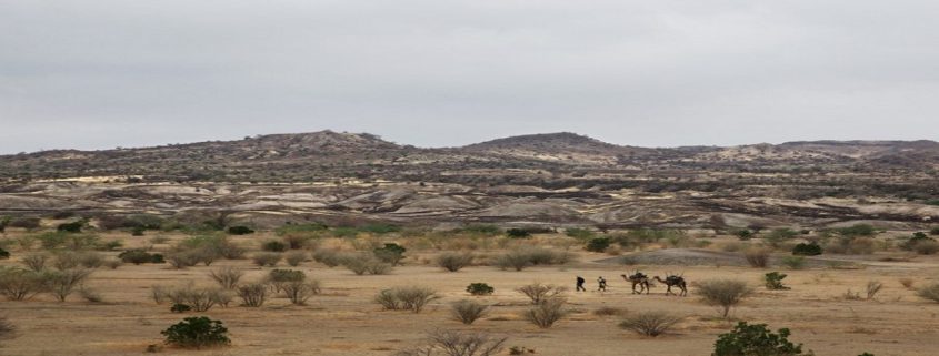
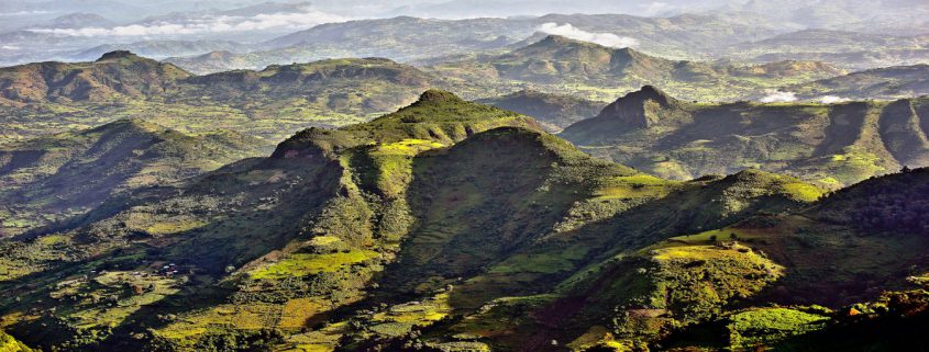
is the monastic settlement of Lalibela on a natural 2,600-metre rock
terrace surrounded on all sides by rugged and forbidding mountains in
the northern extreme of the modern province of Wollo.–Once the thriving
and populous capital city of a medieval dynasty, the passing centuries
have reduced Lalibela to a village. From the road below, it remains
little more than invisible against a horizon dominated by the
4,200-metre peak of Mount Abuna Joseph. –It is this camouflaged,
chameleon quality, however, that gives the remote settlement its special
and lasting place in the life of the highlands – for there, some 800
years ago, safe from the prying eyes and plundering hands of hostile
interlopers, a noble king fashioned a secret marvel. –Lalibela,
previously known as Roha, is named after the king. The word itself,
which translates to mean the bees, recognizes his sovereignty and the
people of the region still recount the legend that explains why.

King Lalibela’s goal was to create a New Jerusalem
for those who could not make a pilgrimage to the Holy Land. According to
some reports, he had been to the Holy Land himself and was inspired by
what he saw. But the king made no attempt to copy the churches of the
Holy Land; in fact, Lalibela’s sacred architecture could not be more
unique.

The churches of Lalibela were not constructed – they were excavated.
Each church was created by first carving out a wide trench on all four
sides of the rock, then painstakingly chiseling out the interior. The
largest church is 40 feet high, and the labor required to complete such a
task with only hammers and chisels is astounding.

Popular legend has it that angels came every night to pick up where the workmen had left off.

King Lalibela’s project for gaining the church’s favor had two
unexpected results: the creation of a holy place of unparalleled beauty
and the king’s conversion to a religious life. After
laboring for more than two decades , he abdicated his throne to become a
hermit, living in a cave and eating only roots and vegetables. To this
day, Ethiopian Christians regard King Lalibela as one of their greatest
saints.

The churches have been in continuous use since they were built in the 12th century.

The roofs of the Lalibela churches are level with the ground and are
reached by stairs descending into narrow trenches. The churches are
connected by tunnels and walkways and stretch across sheer drops. The
interior pillars of the churches have been worn smooth by the hands of
supplicating worshippers.

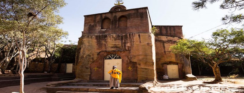
The rock-cut churches are simply but beautifully carved with such features as fragile-looking windows, moldings of various shapes and sizes, different forms of crosses, swastikas (an Eastern religious motif) and even Islamic traceries. Several churches also have wall paintings.

Each church has its own resident monk who appears in
the doorway in colorful brocade robes. Holding one of the church’s
elaborate processional crosses, usually made of silver, and sometimes a
prayer staff.

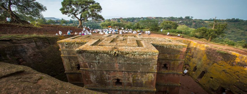
There are 11 rock-cut churches at Lalibela, the most spectacular of which is Bet Giorgis (St. George’s).
Located on the western side of the cluster of churches, it is cut 40
feet down and its roof forms the shape of a Greek cross. It is a
magnificent culmination of Lalibela’s plans to build a New Jerusalem,
with its perfect dimensions and geometrical precision.

Unlike some of the other churches, St. George’s is plain inside.

In the “Northern Group” across the main road from St. George, the most notable church is Beta Medhane Alem, home to the Lalibela Cross and believed to be the largest monolithic church in the world.

Bete Medhane Alem is linked by walkways and tunnels to Beta Maryam (St. Mary’s),
possibly the oldest of the churches. In the east wall of the church is
an array of geometric carved windows in a vertical line. From the bottom
up is: a Maltese cross in a square; a semi-circle shape like that on
the Axum stelae; a Latin cross; and a simple square window.

The windows illuminate the Holy of Holies in which the church’s copy
of the Ark is placed. Other decorations include a Star of David combined
with a Maltese cross, a Sun with a smiling human face flanked by
eight-spoked wheels, Mary on a donkey accompanied by Joseph, and an
Annunciation.

Next to Beta Maryam is Beta Golgotha, known for its
artwork which includes life-sized carvings of saints on the walls. It is
also home to the tomb of King Lalibela, over which stands a gold-draped
Ark. The Western group is completed by the Selassie Chapel and the Tomb of Adam.

Nechisar National Park

Nechisar National Park is situated 510km south of Addis near the
town of Arba Minch, in between Lakes Abaya and Chamo. From the town on
the ridge of land that divides Abaya and Chamo there are commanding
panoramic views all around, including both lakes with Nechisar on the
eastern side and, to the west, the Guge range of mountains. The
outstanding beauty of the neck of land between the two lakes has earned
it the sobriquet of’Bridge of Heaven’. The equally poetic Arba Minch –
meaning ‘forty springs’ – takes its name from the bubbling streams which
spring up amid the undergrowth of the luxuriant groundwater forest that
covers the flats beneath the town. This alluring area is considered one
of Ethiopia’s last great surviving wildernesses.

A wide variety of plains game roam freely amongst 514 km2 of
savannah, dry bush and ground water forest. Animals to be seen are
Bushbuck, Swayne’s Hartebeest, Burchell’s Zebra, Grant’s Gazelle,
Guenther’s Dik-dik, Greater Kudu, Crocodile, Anubis Baboon, Grey Duiker.
Birds seen include Red-billed Hornbill, Grey Hornbil,l Fish Eagle, Kori
Bustard, Abyssinian Ground Hornbill. A backdrop of hills and mountains
combine to make this one of the most attractive national parks in
Ethiopia, and its location makes Nechisar Park very accessible. In the
far eastern part of the Nechisar park is hot springs bubble to the
surface. The shores and islands of Abaya and Chamo are populated by
farming peoples such as the Ganjule and the Guji, both of whom also have
ancient traditions of hippo hunting. The Guji ply the Lake Abaya waters
in elegantly curved high-prowed ambatch boats similar to those depicted
on the tombs of Egyptian phar-aohs. Made of extremely light wood, an
ambatch is capable of transporting several cattle at one time and is
sufficiently sturdy to withstand any attack by crocodiles, which are
present in large numbers – and large sizes – on both lakes.

The vivid contrasts of the Nechisar National Park will linger long in
your memory – a swathe of white grass against the backdrop of clearly
defined, deeply cut hills and mountains. From the escarpment on which
Arba Minch stands you look down on the clear blue waters of Lake Chamo
and the sandy beaches of its northern shores, covered by crocodiles
lounging in the sun.

To the north of Nechisar National Park, Lake Abaya’s surface is a
startling contrast of dark red, caused by the suspended load of ferrous
hydroxide in its waters. At the base of the escarpment is a large area
of groundwater forest around the Kulfo River, as well as the ‘forty
springs’ after which Arba Minch is named. The western edge of the Rift
Valley forms an impressive backdrop to the west. Within the forest are
shy, chestnut-red bushbuck, the comical bushpig, troops of Anubis
baboons, and vervet monkeys.

The most commonly seen creatures of Nechisar’s bush and savannah are
two extremes of antelope: the large greater kudu, with its spectacular
spiral horns and white-striped flanks, and the minuscule Guenther’s
dik-dik.

At first sight the Nechisar plains, which you encounter as you leave
the peninsula between the two lakes, seem surprisingly empty. But
dotting this apparently endless sweep of golden white grass are herds of
Burchell’s zebra, which mingle with Grant’s gazelle and an occasional
Swayne’s hartebeest, an endemic subspecies. Also seen are black-backed
jackal and African hunting dog.

The many and varied bird species reflect the different habitats
within the Nechisar park. As well as their crocodiles and bird life,
lakes Abaya and Chamo are famous for their sport fishing potential,
especially for Nile perch – often weighing more than 100 kilos (220
pounds) – and for the fighting ‘tiger fish’.

MAMMALS :In the park 91 species of mammals have been
described. Common zebra, Swayne’s hartebeest, Grants gazelle, greater
kudu, Guenther’s dikdik, common bushbuck, Colobus monkey, and
hippopotamus are the most interesting ones for the visitor. The large
herds of zebra in the Nechisar plains are one of the landmarks of the
park.

BIRDS :The park harbors at least 351 bird species ,
some of them little known in Ethiopia: white-tailed lark , the endemic
Nechisar nightjar and the rare star-spotted nightjar. Especially the
Nechisar nightjar remains an enigma. Only one wing was ever found, no
one has yet seen the live animal.

FISH

A total of 16 species are generally recorded for both Abaya &
Chamo Lakes and of these, two are endemic to Ethiopia, the Labeo
Brunelli and the Marcusenius Annamaariae.

REPTILES: Considerable number of snakes, lizards,
tortoises and frogs are found in the Park. A total of 21 species of
snakes including the African egg-eater occurs in the area.

MAGO NATIONAL PARK

Located about 800 kilometers south of Addis Ababa and on east bank
of Omo river, the 2,162 square kilometers of this park are divided by
the Mago River, a tributary of the Omo, into two parts. To the west is
the Tama Wildlife Reserve, with the Tama river defining the boundary
between the two. To the south is the Murle Controlled Hunting Area,
distinguished by Lake Dipa which stretches along the left side of the
lower Omo. The park office is 115 kilometers north of Omorate and 26
kilometers southwest of Jinka. The park has about 200km internal roads,
which lead to the different attractions sites of the park. All roads to
and from the park are unpaved.

Most easily accessed from the town of Jinka, Mago National Park is
mainly savannah, with some forested areas around the rivers. It was set
up to conserve the large numbers of plains animals in the area,
particularly buffalo, giraffe, and elephant. Also seen here are topi and
lelwel hartebeest, as well as lion, leopard, Burchell’s zebra, gerenuk,
and greater and lesser kudu. The birds are also typical of the dry
grassland habitat, featuring bustards, hornbills, weavers, and
starlings. Kingfishers and her-ons feed in and around the Neri River,
which provides an alternative habitat.

The major environments in and around the Mago Park are the rivers and
riverine forest, the wetlands along the lower Mago and around Lake
Dipa, the various grasslands on the more level areas, and scrub on the
sides of the hills. Open grassland comprises about 9% of the park’s
area. The largest trees are found in the riverine forest beside the Omo,
Mago and Neri. Areas along the lower Omo (within the park) are
populated with a rich diversity of ethnic groups, including the Aari,
Banna, Bongoso, Hamer, Karo, Kwegu, Male and Mursi peoples. The park’s
perhaps best known attraction are the Mursi, known for piercing their
lips and inserting disks made of clay.

Wildlife: the Park supports a typical bush savanna
fauna with 81 larger mammals & 237 species of bird. Among mammals:
African elephant, buffalo, lesser-kudu, greater-kudu, duiker, warthog,
tiang, lewel’s hartebeests, Oryx, grant’s gazelle, gerenuk, giraffe,
cheetah, wild dog, lions, leopards, gureza, common baboon and verevt
monkey are common & conspicuous.

Access:The Park is 800km and 500 km from to the
south of Addis Ababa and Hawassa, respectively. The road from Jinka town
to the park covers a distance of 34km all weather gravel road. The park
has about 200km internal roads, which lead to the different attractions
sites of the park.

Surrounding Community

MNP area is also very well-known for its rich cultural diversity,
where many elements of the earliest nomadic lifestyles are still
continued. Hammer, Benna, Mursi, Ngagatom, Ari, Karo, Body, Kwegu are
communities very well known for their traditional culture, lifestyles,
colorful body decoration, ceremonies, festivals, rituals, and other
living expressions.

Harar , the Fortified Historic Town

The fortified historic town of Harar is located in the eastern
part of the country on a plateau with deep gorges surrounded by deserts
and savannah. The walls surrounding this sacred Muslim city were built
between the 13th and 16th centuries. Harar Jugol, said to be the fourth
holiest city of Islam, numbers 82 mosques, three of which date from the
10th century, and 102 shrines, but the townhouses with their exceptional
interior design constitute the most spectacular part of Harar’s
cultural heritage. The impact of African and Islamic traditions on the
development of the town’s building types and urban layout make for its
particular character and uniqueness.

An incredible feature of Harar is the ‘Hyena Man’, who bravely feed
the erratic beasts by hand and mouth, each evening on the outskirt of
the city.

You can expect to see more than 10 Hyenas in one particular hyena
feeding ritual and if you are brave enough, you can try it yourself, few
fearless travelers do, and that is an adventure indeed!

So if you are up to for the adventure of a lifetime, nature devotee
and city types, Harar and Eastern Ethiopia as a whole is the place to
visit.

Hyena-feeding

The Eastern part of the country is dry, hot, wild and Muslim. It
contains magnificent landscapes, cities cloaked with a flagrant
historical aura and mystery and a pervading sense of adventure. If one
place had to be singled out, it would be Harar, the gem of the place.

Before the nightfall and meet the Harar Hyenas, getting ecstatically
lost in Harar’s captivating history by wandering through the mesmerizing
alleyways along with the aroma of the best coffee in Ethiopia “actually
in the world” that winding through the streets, make it all worth the
visit. Let us start with the distinct architectural feature in Harar; it
is the fascinating traditional Harari (Adare) houses and it is a must
see.

Harar is the city that can be visited at any time of year and it is a
city many foreigners inhabit among them is the famous French poet
Arthur Rimbaud, who spent some of his last year in the city.

An incredible feature of Harar is the ‘Hyena Man’, who bravely feed
the erratic beasts by hand and mouth, each evening on the outskirt of
the city.

You can expect to see more than 10 Hyenas in one particular hyena
feeding ritual and if you are brave enough, you can try it yourself, few
fearless travelers do, and that is an adventure indeed!

So if you are up to for the adventure of a lifetime, nature devotee
and city types, Harar and Eastern Ethiopia as a whole is the place to
visit.

Hamer

Cultural tours of Ethiopia enable onto understand the harmonious
diversity of the nation. There are 83 languages and 200 dialects spoken
throughout Ethiopia. The culture in Ethiopia is truly exotic, untouched
and authentic. Far from the modern life, the people in far field are
with natural and rustic life style that feels our origin.

Ethiopia is a mosaic of cultures for cultural tourists. The Lower Omo
Valley in the South of Ethiopia is perhaps one of the most
ethnographically diverse regions in the world. It served as an ancient
meeting point as tribes migrated from all corners of Africa and now
plays host to many different tribes each with unique and fascinating
customs. If you can handle the challenges of travelling in this remote
region, then the rewards are immense. Whether you are watching the
traditional ceremony of Hamer people jumping the Bulls or gazing
incredulously at the site of a Mursi’s lip plates, this is a place
unlike anywhere else on Earth.

The landscape and wildlife of the Lower Omo Valley is an attraction
in itself, terraced richly vegetated areas contrast with open savannah
and despite widespread poaching, hippo (Lake Chomo) and dik dik, kudu,
guinea fowl, gerenuk and various birds are frequently seen. The real
reason for the journey though is in the contrast of cultures and
learning about the traditional customs of peoples far removed from your
own lifestyle.

Hamer:- The Hamer who number around 50,000, are subsistence
agro-pastoralists. They cultivate sorghum, vegetables, millet, tobacco
and cotton, as well as rearing cattle and goats. Wild honey is an
important part of their diet.–The people are known particularly for
their remarkable hairstyles. The women mix together ochre, water and a
binding resin, rub the mixture into their hair, then twist strands again
and again to create coppery-colored tresses known as goscha. These are a
sign of health and welfare.–If they have recently killed an enemy or a
dangerous animal, the men are permitted to don clay hair buns that
sometimes support magnificent ostrich feathers. The buns — with the help
of special headdress (borkotos) for sleeping — last from three to six
months, and can be ‘redone’ for up to one year.The Hamer are also
considered masters of body decoration. Every adornment has an important
symbolic significance; earrings for example, denote the number of wives a
man has.

The women wear bead necklaces, iron coils around their arms, and
decorate their skin with cowry shells. The iron torques around their
necks are known as ensente and are worn by married or engaged women
only. They indicate the wealth and prestige of the woman’s husband.
Young, unmarried girls wear a metal plate in their hair that looks a bit
like a platypus’ bill.–The iron bracelets and armlets are an indication
of the wealth and social standing of the young girl’s family. When she
gets married, she must remove the jewellery; it is the first gift she
makes to her new family.–The Hamer territory stretches across the plains
of the Lower Omo to Chew Bahir in the east, almost to the Kenyan border
in the south, and to the territory of the Benna in the north.

The Karo:- The Karo people thought to be one of the most endangered
groups the Omo, with a population of about 1500 people. They inhabit the
eastern bank of the Omo. They were formerly pastoralists, but many of
their cattle have been wiped out by disease, and many have turned to
agriculture.In appearance, language and tradition, they slightly
resemble the Hamer, to whom they are related. The Karo are considered
masters of body painting, in which they engage when preparing for a
dance, feast or celebration. Most famously, chalk is used to imitate the
spotted plumage of the guinea fowl.The Karo are also great improvisers:
Bic biros, nails, sweets wrappers and cartridges are all incorporated
into jewellery and decoration. Yellow mineral rock, black charcoal and
pulverized red iron ore are traditionally used.

The Mursi :Perhaps the best known of the Omo peoples are the Mursi,
thought to number around 6500, are mainly pastoralists who move
according to the seasons between the lower Tama Steppe and the Mursi
Hills in Mago National Park.––Some Mursi practice flood retreat
cultivation, particularly in the areas where the tse tse fly prohibits
cattle rearing. Honey is collected from beehives made with bark and
dung. The Mursi language is Nilo-Saharan in origin.–The most famous
Mursi traditions include the fierce stick fighting between the men, and
the lip plate worn by the women which is made of clay and often quite
large, the plates are inserted into slits in their lower lips.
Anthropologists offer several theories to explain the practice: to deter
slavers looking for unblemished girls; to prevent evil from entering
the body by way of the mouth; or to indicate social status by showing
the number of cattle required by the wearer’s family for her hand in
marriage.

GONDAR African Camelot

The Center of Ethiopian art and culture Gondar, founded by Emperor
Fasilidas around 1635, is famous for its many medieval castles and the
design and decoration of its churches – in particular, Debra Berhan
Selassie which represents a masterpiece of the Gondarene school of
art.–Famous though Gondar may be, however, no one knows exactly why
Fasilidas chose to establish his headquarters there. Some legends say an
archangel prophesied that an Ethiopian capital would be built at a
place with a name that began with the letter G. The legend led to a
whole series of sixteenth- and seventeenth-century towns – Guzara,
Gorgora and finally Gondar. Another legend claims that the city was
built in a place chosen by God. Apparently, He pointed it out to
Fasilidas who was on a hunting expedition and followed a buffalo to the
spot. –Flanked by twin mountain streams at an altitude of more than
2,300 meters Gondar commands spectacular views over farmlands to the
gleaming waters of Lake Tana thirty-five kilometers to the south. The
city retains an atmosphere of antique charm mingled with an aura of
mystery and violence. An extensive compound, near its center contains
the hulking ruins of a group of imposing castles like some African
Camelot.

The battlements and towers evoke images of chivalrous knights on
horseback and of ceremonies laden with pageantry and honor. Other,
darker, reverberations recall chilling echoes of Machiavellian plots and
intrigues, tortures and poisonings. –The main castle was built in the
late 1630s and early 1640s on the orders of Fasilidas. The Emperor, who
was greatly interested in architecture – St Marys in Axum was another of
his works – was also responsible for seven churches, a number of
bridges, and a three-story stone pavilion next to a large, sunken
bathing place, rectangular in shape, which is still filled during the
Timkat season with water from the nearby Qaha river.–Other structures
date from later periods. Iyasu the Great, a grandson of Fasilidas, was
particularly active. His castle, centrally located in the main compound,
was described at the time by his chronicler as finer than the House of
Solomon. Its inner walls were decorated with ivory, mirrors and
paintings of palm trees, its ceiling covered with gold-leaf and precious
stones. Now gutted, haunted only by ghosts, the intact turrets and
towers of this fine stronghold reflect its past glory. –Iyasus most
lasting achievement, was the Church of Debra Berhan Selassie, the Light
of the Trinity, which stands, surrounded by a high wall, on raised
ground to the north-west of the city and continues to be in regular use.
A plain, thatched, rectangular structure on the outside, the interior
of Debra Berhan Selassie is marvelously painted with a great many scenes
from religious history. The spaces between the beams of the ceiling
contain the brilliant wide-eyed images of more than eighty angels faces –
all different, with their own character and expressions. The north
wall, in which is the holy of holies, is dominated by a depiction of the
Trinity above the crucifixion. The theme of the south wall is St Mary;
that of the east wall the life of Jesus. The west wall shows important
saints, with St George in red-and-gold on a prancing white horse.–Not
long after completing this remarkable and impressive work, Iyasu went
into deep depression when his favorite concubine died. He abandoned
affairs of state and his son, Tekla Haimanot, responded by declaring
himself Emperor. Shortly afterwards, in 1706, his father was
assassinated on his orders. –In turn, Tekla Haimanot was murdered. His
successor was also forcibly deposed and the next monarch was poisoned.
The brutalities came to an end with Emperor Bakaffa who left two fine
castles – one attributed directly to him and one to his consort, the
Empress Mentewab.