Gambella National Park

At a road distance of 850 km Gambela – Addis Ababa, the 50,600 ha
Gambella National park is located 850 km west of Addis Ababa, the 50,600
hectares Gambella National park has the richest mega
wildlife of the parks in Ethiopia. It was established as a protected
area in 1973 to conserve a diverse assemblage of wildlife and unique
habitats. Although not technically in the Rift Valley, Gambella National
Park lies along another of the country’s important rivers: the Baro.
Near the town of Gambella, Gambella National Park, is one of Ethiopia’s
least developed parks and has no facilities. Nevertheless, the large
conservation area contains many species not found elsewhere in the
country, such as the Nile lechwe and the white-eared kob. Roan antelope,
topi, elephant, buffalo, giraffe, and the unusual whale-headed stork
are also to be found here.

Originally the park was created for protection of extensive swamp
habitat and its wildlife. Located on the Akobo river system, it hosts
several wildlife not found elsewhere in Ethiopia. The banks of the baro
are rich in birdlife and thus give visitors an extra advantage. Its
northern boundary is formed by the Baro River. To the south of the park
is the Gilo River flows from Gog to Tor in a northwesterly direction.

The landscape of Gambella is low and flat with altitude ranging from
400 to 768 masl. The average altitude is around 500 meters above sea
level.

The people of this area are the Anuak and the Nuer. Mainly fisherfolk
– but also cattle herders – the Anuak and Nuer are extremely handsome,
with dark, satiny complexions. Both men and women favour a style of
decorative scarification on the chest, stomach, and face; and often
boast heavy bone bangles, bright bead necklaces, and spikes of ivory or
brass thrust through a hole pierced in the lower lip and protruding down
over the chin.

Unaffected by the ways of the modern world, these interesting people
remain as remote, unchanged, and beautiful as the land in which they
live.

Wildlife

41 larger mammals are known including Buffalo, Elephant, White-eared
Kob, Hippopotamus, Nile Lechwe, Giraffe, Warthog, Topi, Waterbuck, Roan
Antelope,  Burchell’s Zebra, Bushbuck and Reedbuck. The rivers host
healthy populations of Nile Crocodiles. Gambella has more than 300 bird
species, obviously including water birds like the Shoebilled Heron,
Basra Reed Warbler and Demoiselle Crane. Nile perch weighing more than
100 kg have been caught from the Baro River.

Climate of Gabella National park

The climate of Gabella is hot and humid with maximum temperatures
just before the rainy season in May. Annual mean temperature is with a
minimum and maximum of 20.4 and 34.8 0 C, respectively. Annual rainfall
is about 1400 mm. The wet season is from May to October when large parts
of the park are totally inaccessible.

Ethiopia:Historical journey in time from 10th BC to present civilization

Ethiopia is a land of contrast and extreme diversity. From the
lowest lowland on earth to the second highest mountain in Africa, from
the least complicated fascinating tribes of southern Ethiopia to the
capital city and headquarter of Africa, Ethiopia is quite a contrast of
historical, cultural and natural attractions.

Traveling in Ethiopia is the same as traveling through time. The rich
history of northern Ethiopia – Axum, Lalibela, Gondar, Bahir Dar,
Harrar and others dates back more than 3000 years. The fascinating
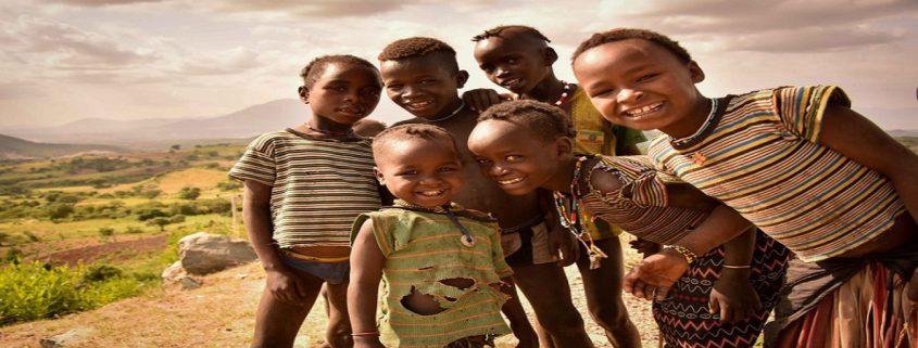
tribes of southern Ethiopia – Konso, Mursi, Surma, Hamer and others make
you fall in love with the originality and simplicity of different human
living styles.

All these, coupled with the breathtaking natural scenery and wildlife
abundance of the country, makes Ethiopia a first travel site to be
visited in Africa.

Ethiopia is the earliest known home of humankind. A skeleton of an
older human ancestor Australopithecus Afarensis was discovered in 1974
in the Afar region. Anthropologists have established that the skeleton
covering 40% of the human body had belonged to a twenty-years-old female
that lived 3.5 million years ago. Registered by UNESCO as a World
Heritage, the site of the discovery is called Hadar.The Skeleton is
popularly known as Lucy or Dinkinesh. The discovery has completed the
missing link between apes and men – paving the way for the search to
human origins.

In addition, the earliest known hominid, 4.4 million years old
Ardipithecus Ramidus was discovered in the Middle Awash in 1992. The
recent discoveries include Australopithecus Garhi, 2.5 million-years-old
hominid. Garhi means ‘surprise’ in the Afar language – a language
spoken in the internationally acclaimed archeological site.

Independent for three millennia, Ethiopia has survived dynamic
historic changes and is the birthstone of great endogenous
civilizations. Today’s Ethiopia was once in control over the entire East
African territory. At that time it was a world-famous influential
powerhouse with absolute control over the Red Sea, Indian Ocean trade
routes and South Arabian countries Ethiopia is a country of variety,
extremes, uniqueness, freedom, colourful culture, religions, legends,
natural beauty and much more. On the map of East Africa, Ethiopia is
easily found in the area called the horn of Africa. Covering a total
area of 1,112,000 sq. km., Ethiopia shares boundaries with Kenya, Sudan,
Somalia, Djibouti and Eritrea. Ethiopia ranks second in Africa for
population size. With close to 87 million people, Ethiopia hosts about
83 different tribal groups, all of which speak different languages and
have their own cultural codes. The cultural variety, which is a result
of immense tribal differences, can be seen among the individual tribes.
Rich in culture and a variety of dialects, Ethiopia prides itself on
being the only nation in Africa to have its own language (Amharic) and
alphabet (Ge’ez).

Ethiopia was the first country to build a Christian church on African
soil. Christianity crossed the border in the 4th Century AD during the
time of the Axumite kingdom. Even now this church shelters the original
Ark of the Covenant brought from Israel by King Menelik I of Ethiopia.
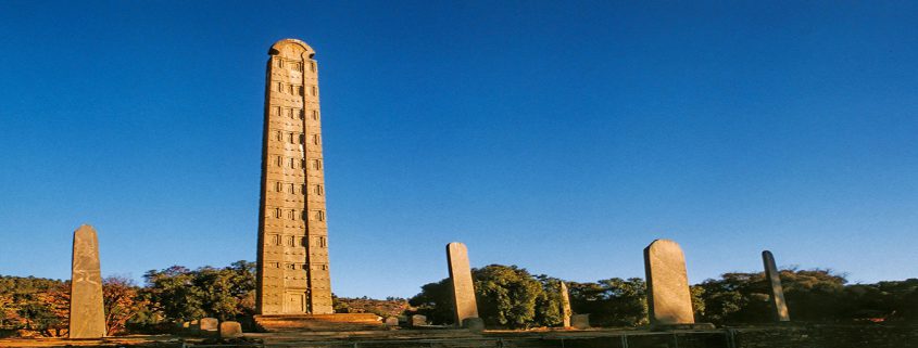
It is found in the town of Axum in northern Ethiopia. In addition it is
here that the famous pre-Axumite obelisks stand. It is believed that the
erection of these obelisks dates back to 300-200 BC. The tallest (33m)
has fallen down; the second (27m) was stolen but the third (23m) still
stands. These structures are the tallest on earth to be carved out of a
single rock.The 12th-century town of Lalibela, located in north-west
Ethiopia, has been home to the extraordinarily carved rock-hewn churches
since the reign of King Lalibela (1181-1221 AD). These eleven rock-hewn
churches are sometimes referred to as the eighth wonder of the world.

Gondar, the town of castles and the 17th century Ethiopian capital,
has great historical significance. It was here that King Fasiladas
relocated the former capital. The best example of a medieval-period
church is that of Debre Berhan Selassie, which adds to Gondar’s charm.

Southwards, the Rift Valley system is another wondrous region where
many other attractions are sited. The six or seven Rift Valley crater
lakes are home to a large number of bird and marine life. They are also a
paradise for nature and water lovers. National parks with their exotic
birds, animals and plant life add to the beauty of the Rift Valley
region. Beautiful landscapes and natural features are the most enjoyable
components of the system. Salt lakes, active volcano sites and caravan
routes still number among Ethiopia’s great attractions in the Rift
Valley.

Further south is the Omo Valley with its popular ethnic treasures.
This is where about 50% of Ethiopia’s ethnic groups live: the Konso with
their terraced agriculture and rituals; the Mursi with their clay lip
plates and barbarian life style; the Hamer with their bull-jumping
ceremony, which young men must experience in order to qualify for
adulthood; and the Karo with their body painting and adornment. Here
unusual traditions such as dance, music and rituals from birth to
marriage and burial are still observed in their genuine and original
forms.

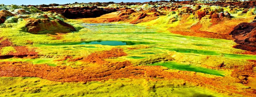
Nothing in this planet is quite as spectacular as the Danakil
Depression. Bubbling volcanoes light up the night sky, sulphurous mounds
of yellow contort into monstrous shapes and mirages of camels cross
lakes of salt. Laying 100m below sea level the Danakil depression is
about the hottest and most inhospitable place on earth. This will be the
best opportunity to visit the fascinating religious celebrations.

Ethiopian World heritage sites

According to the UNESCO World Heritage list, Ethiopia has the biggest
number of world heritage sites in Africa. With a total of nine natural
and cultural heritage sites the country tops the list.

Ethiopia and Morocco are first and second, respectively, among
African countries on the UNESCO World Heritage list. Although they both
have nine world heritage sites each, Ethiopia has been ranked higher
because of two main reasons.

Ethiopia not only has the highest number of world heritage sites on
the African continent, but one of the sites, the Rock-Hewn Churches of
Lalibela, was one of the first sites that were chosen as a heritage site
for the African continent at the list’s conception.

Among Ethiopia’s sites on the list of World Heritage Sites, UNESCO
has made attempts to increase the awareness of the importance of the
African human origin sites in Ethiopia. The aim is to conserve and
protect the areas from deteriorating.

The full list of Ethiopia’s natural and cultural heritage sites on
the UNESCO World Heritage Sites list (by year of inscription):

1-The Rock-Hewn Churches of Lalibela (1978)

Located in Lalibela, a town in the Amhara Region, the site is home to 11 medieval cave churches that were built in the 12th
century. Built during the reign of King Lalibela it was intended to
create a new Jerusalem after the capture of the original Jerusalem in
1187 – hence Lalibela also being known as “New Jerusalem”. The plan
appeared to the saint king in his dreams.

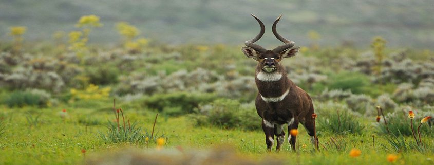
 2- Simien Mountains National Park (1978)

The only natural heritage site in Ethiopia is also located in the
Amhara Region of the country. The territory of the park encloses the
Simien Mountains range that includes Ethiopia’s highest – Mount Ras
Dashen. The park is home to a multitude of endangered species. Among
them are the Ethiopian Wolf (also known as the Red Jackal), the walia
ibex, the gelada baboon – all which are endemic to Ethiopia – and the
caracal.

At the moment, this natural heritage site is the only one of the
Ethiopian natural or cultural heritage sites that is also on the UNESCO
List of World Heritage in Danger.

The Simien Mountains National Park was established in 1969 by Clive
Nicol who wrote about his experiences in his book From the Roof of
Africa.

 3-Gondar (1979)

Fasil Ghebbi is a fortress and castle that is located in Gondar, a
city in the Amhara Region of Ethiopia. It was built by Emperor Fasiledes
who ruled Ethiopia from 1632 to 1667.

Covering an area of 70,000 Sq. m. Fasil Ghebbi also has many
structures in its enclosure. It has palaces, churches and monasteries
and even a market place. The first person to observe that “dotted among
the palaces are what remains of the pavilions and kiosks of the imperial
city” was Thomas Pakenham (Author of The Mountains of Rasselas:
Ethiopian Adventure) who visited Fasil Ghebbi in the late 1950’s. The
city has a mixture of building styles from Arab, Hindu to the Baroque
style that was brought by Jesuit missionaries.

 4-Axum (1980)

Axum is a city that is located in the Tigray Region of Ethiopia. It
is the site of royal tombs, ruins of castles and, most importantly,
stelae and obelisks that date from the 1st to the 13th
centuries that were built during the time of the ancient Axum Empire –
one that was said to have given birth to the a state that was the most
powerful one between the Eastern Roman Empire and Persia.

Axumites traded with ancient Greeks, Egyptians and Asians. They had fleets that sailed as far Ceylon (Sri Lanka).

 5-Lower Valley of the Awash (1980)

The Lower Valley of the Awash can be considered the exact location of
where mankind was born. Located in the Afar Region of Ethiopia, it is
the place where the approximately 3.2 million years old Lucy (Australopithecus) was discovered in 1974.

A place that has yet to yield all of its secrets was to also be the place where Ardi (Ardipithecus ramidus), a fossil that was 4.4 million years old (1.2 million years older than Lucy), would be found in 1994. In 2000 Selam (Austrolopithecus afarensis) or “Lucy’s baby” (despite the fact that she dies about 120,000 years before her) would be discovered.

Lucy, mankind’s earliest fossil, was given the name because after
discovering her Donald Johanson and his crew were celebrating in camp
and were listening to “Lucy in the Sky with Diamonds” – a popular
Beatles song.

 6-Lower Valley of the Omo (1980)

This cultural heritage site is located in the Southern Nations,
Nationalities, and People’s Region in the southern part of Ethiopia. It
is the location of many fossil findings, the most famous of them being Homo gracilis.

On the banks of the Omo River archeologists have found fossil fragments like the important finding of the now extinct Australopithecus man and Olduwan hominids of the early Pleistocene era.

The Omo region is the yardstick by against which
all other ancient deposits in East Africa are measured by. Evidence was
researched for the site to establish bio-stratigraphical, radiometric
and magneto-stratigraphical scales spanning between one and 3.5 million
years.

 7-Tiya (1980)

Another cultural heritage site in the Southern Nations,
Nationalities, and People’s Region Tiya is also an archeological site.
The site contains 36 monuments (including 32 carved stelae that, as of
date, are covered with symbols that have not been decrypted). It is
assumed that the stelae are of funerary significance because there are
tombs scattered around the stelae.

The site is from an age of ancient Ethiopian culture that is yet to be precisely determined.

8-Harar Jugol (2006)

Harar Jugol is a fortified historic town that is found in the Harari
Region of Ethiopia that was founded by Arab immigrants from Yemen in the
7th century. The city is encircled by a wall. It encompasses
102 shrines and 82 mosques making it considered to be the
fourth-holiest city of Islam. Some of the mosques date back to the 10th century.

When the Addis Ababa – Djibouti Railway was being built it was
intended to run through Harar. But because of geographical and financial
constraints the line had to be diverted away and the city of Dire Dawa
was born in 1902. It is sometimes known as “New Harar“.

 9-Konso Cultural Landscape (2011)

The Konso Cultural Landscape, found in the Southern Nations,
Nationalities, and People’s Region, is a cultural site that features 55
kilometers of stonewalled terraces and fortified settlements in the
Konso highlands of Ethiopia.

The fortified settlements constitute of a spectacular example of
living in a cultural tradition that stretches back 21 generations (more
than 400 years). The whole area demonstrates the shared values, social
cohesion and engineering knowledge of the people.

It also the ingenuity of mankind and how he can not only survive but also thrive in a hostile (dry and rocky) environment.

The terraces are used to not only retain the maximum amount of water
needed but to also discharge the excess – all this while protecting the
soil from erosion.

Danakil Depression Looking into the bowel of the Earth

The Danakil Depression is a desert area in the Afar region of northeastern Ethiopia, north of the Great Rift Valley .

This is both the hottest region on earth averaged year round and one of the most geologically active.

This is the land of “Ardi” (Ardipithecus ramidus) and “Lucy” (Australopithecus afarensis)
– hominids which have been proposed as among our first putative
ancestors. In June 2010, the oldest direct evidence of stone tool
manufacture was found in this region and attributed to Australopithecus afarensis hominids dating back more than three million years ago.

Near the southern end of the Red Sea an immense, more or less
triangular, depression descends far below sea level – some points near
the ghost town of Dallol are nearly 116m below sea level). Known as the
Danakil/Dallol Depression, the northern part is extremely hot and dry
and an extension of the Great Rift Valley. In this seemingly
inhospitable area live the nomadic Afar people who number about 3
million.

The whole Afar Depression is a plate tectonic triple junction where
the spreading submarine ridges that formed the Red Sea and the Gulf of
Aden emerge on land and meet the East African Rift. The Afar Depression
is one of two places on Earth where a mid-ocean ridge can be studied on
land. At present, the Afar is slowly being pulled apart at a rate of
1-2cm per year. The floor of the Afar Depression is composed mostly of
basaltic lava. The Afar Depression and Triple Junction also mark the
location of a mantle plume, a great uprising of the earth’s mantle that
melts to yield basalt.

This place, which used to be part of the Red Sea, has kilometres of
salt deposits. In some places the salt deposits are about 5km (3 mi)
thick. Below many salt lakes are substantial sources of volcanic heat
which causes hot water to rise through layers of salt and deposit
anhydrites. Minerals also get dissolved and are deposited near the
springs, and form shapes very much reminiscent (but smaller than)
hornitos on basaltic lava flows. Sulphur, other minerals and possibly
Thermopylae bacteria cause spectacular colours. Acid pools and deposits
of salt, sulphur and other minerals at Dallol. This is a vast expanse of
blisteringly hot desert with lava flows and salt plains and lakes that
lie below sea level. Active and extinct volcanoes lie along a
south—north axis with the extremely salty Lake Afrera, at 120m below sea
level, kept alive by the many thermal springs feeding it.

Dallol — the lowest & hottest point on the planet

The Danakil Desert is located between the Ethiopian plateau and the
Red Sea. The salt plain near Dallol is the lowest part at 116 meters
below sea level. –In prehistoric times, the territory was in the form of
a gulf. According to geologists, this is a sea bed that emerged for a
brief moment in the history of the planet; the Afar depression will in
fact form a future ocean with the Red Sea and the Gulf of Aden. –This
geological anomaly means that the entire area is very unstable. There
are numerous active volcanoes and frequent earthquakes, /together with
secondary manifestations such as the stupendous colours of the salt
surfaces, caused by the geysers with their various different chlorides.
–This inhospitable territory is home to nomadic sheep-herding Afar
people. –This tribe has a strong sense of its own identity and enjoys a
notable degree of autonomy in its land. The Afar live from their
animals, agriculture and the sale of salt that they extract from the
salt lakes of the Danakil depression. The salt is loaded onto camels and
sold in the markets of the highlands.

Dallol offers an opportunity to see the first signs of a new ocean
basin forming. The Dallol volcano, the only volcanic crater below sea
level on land, has remained dormant since 1926, as the seabed it will
one day occupy gradually widens. South of Dallol, rectangular salt slabs
are cut and transported up into the highlands in a near endless
procession of camel caravans. The salt canyons south of Dallol Mountain
are some of the most impressive geological features in the area. It
looks like another planet because there are lots of colourful rocks in
each metre of terrain. It looks like something out of a science fiction
novel.

The town of Dallol, built from salt blocks and
which almost straddles the Eritrean border to the east of the Tigrayan
highlands, is officially listed as the hottest place on Earth, with an
average annual temperature of 35 degrees Celsius and hottest daily
temperatures topping 40°C year round. Much of this vast and practically
unpopulated region lies below the driest and most tectonically active
areas on the planet. The Danakil is an area of singular geological
fascination. A strange lunar landscape studded with active volcanoes
malodorous sulphur-caked hot springs. Solidified black lava flows. And
vast salt encrusted basins. It is some measure of the Danakil’s
geological activity that more than 30 active or dormant volcanoes
roughly one quarter of the total as listed by the Smithsonian instituted
global volcanism program. These volcanoes are all geological infants
having formed over the past million years and with a great many taking
their present shape within the last 10,000 years.

Erta Ale – the living Shield Volcano

Location: Lat. 13.6N, Long. 40.7E–Elevation:
2,011 feet (613 m)–Erta Ale is a very remote and rarely visited shield
volcano in the Afar region of East Africa. It is Ethiopia’s most active
volcano and it has been in a state of continuous eruption since 1967.
Daytime temperatures will likely be above 40 degrees Celcius and the
base of the volcano actually lies below sea level and it’s summit rises
up to 613 Meters. Erta Ale is known for it’s 2 pit craters which have
had active lava lakes in the past. –Erta Ale has undergone seven
eruption events in the past 125 years. Three of the early eruption
dates, 1873, 1903, and 1904 are uncertain. However, 1906, 1940, 1960,
and 1967 are well established events. Erta Ale has been erupting
continuously since 1967. –Two new studies on Erta Ale have recently been
published. Oppenheimer and Francis (1998) looked at the implications of
long-lived lava lakes. They believe that Erta Ale’s lava lake has been
active for at least the last 90 years (making it one of the longest
known historic eruptions). Large amounts of heat are released by the
volcano but the amount of lava that erupts is relatively small.
Oppenheimer and Francis speculated that a higher magma density (caused
by the cooling of the lava in the lake) inhibits eruptions. They
proposed that most of the magma accumulates in the underlying crust in
the form of dikes and sills. Since the Afar region is under extension,
conditions are favorable for the injection of dikes and sills. –Barrat
and others (1998) looked at the chemistry of the rocks at Erta Ale.
Rocks range in composition from basalt to rhyolite. Barrat and others
found that two mantle sources were tapped for the basalts: one similar
in composition to the source for mid-ocean ridge basalts (called MORB by
geochemists) and one similar in composition to the source for
ocean-island basalts (called OIB). Their data did not show a significant
contribution of sialic material from the continental crust.

Bale Mountain National Park

Lying south-east of Ethiopia, Bale Mountains National Park covers
2400 square kilometers (1488 square miles) covering wide range of
habitats and ranging in altitude from 1500 to 4377 meters (4920 to 14357
feet) at Tulu Dimtu, the highest point in the southern Ethiopia. The
spectacular Harenna escarpment running from east to west divides the
area into two major parts. To the north is a high altitude plateau area
known as the Sanetti Plateau (4000m) formed of ancient volcanic rocks
and dissected by many rivers and streams that have cut deep gorges into
the edges. In some places this has resulted in scenic waterfalls and
alpine lakes.
The vegetation here varies according to altitude.

The park can be divided into three main zones. Around Dinsho, in the
north, there are grass riverine plains, bordered by bands of bushes,
particularly sagebrush and St. John’s Wort. Wild flowers, such as Giant
Lobelia, Geraniums, ‘red-hot pokers’ and Alcheilla, form carpets of
color. Higher up the mountains heather appears either as small bushes or
as mature trees.
The second zone, the Sanetti Plateau, is home to
typical Afro-Alpine plants, some coping with the extreme temperatures by
either remaining very small or becoming large. The best example of the
latter is the curious looking Giant Lobelia, whose stems stand high
against the skyline. Wild flowers are many and various, the dominant
plant being the Helichrysum, or ’everlasting’ flowers that can be seen
in many forms. Keep an eye on the indigenous Abyssinia rose, with its
lovely subtle scent.

The Bale Mountains National Park in central Ethiopia remains
relatively undiscovered by even the most adventurous travellers, who
tend to explore the Simien Mountains in the north and the Rift Valley
Lakes in the south. This is in part due to poor access and limited
accommodation. Now, a new road has cut the journey time from the Rift
Valley Road from 10 hours to one, and at the end of it the first
high-end lodge has open.

The stream also brings rich wildlife watching: 240 species of bird,
mountain nyala (antelope), warthogs and Bale monkeys are in abundance.
There’s a research centre with a naturalist and ornithologist who spends
the day studying the park’s endemic species, and gives talks to guests
in the evenings. Not far away is the Sanetti Plateau, where endangered
Ethiopian wolves – 300 of the 500 left in the wild – can sometimes be
spotted hunting rodents in the snow.

Bahir Dar – Lake Tana Monasteries and Blue Nile falls

The Lake Tana /BAHIR DAR/ and The Blue Nile Falls
– the Source of the most famous river in the World. Lake Tana, the
largest lake in Ethiopia, situated north of the beautiful town of Bahir
Dar is the source from where the famous Blue Nile starts its long
journey to Khartoum, and on to the Mediterranean.

The 37 mysterious islands that are scattered about the surface of the
lake, give shelter to well hidden churches and monasteries of immense
historical and cultural interest; decorated with beautiful paintings and
housing innumerable treasures.

Along the lakeshore bird life, both local and migratory visitors,
make the site an ideal place for birdwatchers. The whole of the lake
Tana region and the Blue Nile gorge host a wide variety of birds both
endemic and migratory visitors. The variety of habitats, from rocky
crags to riverside forests and important wetlands, ensure that many
other different species should be spotted.

Restorative work explains the Gondarene character of some of the
paintings found in the remarkable monasteries and churches on the
islands of Lake Tana. –Kebran Gabriel, for example, originally
established in the fourteenth century, was later renovated and rebuilt
during the reign of Emperor Iyasu I (1682-1706). Narga Selassie, built
in the eighteenth century by Empress Mentewab, is also Gondarene in
character. Other churches are influenced by different periods. For
instance, although Ura Kidane Mehret on the Zegie Peninsula is a
fourteenth-century building, its most powerful murals notably around the
holy of holies – were painted in Gondarene times.

On the other hand, the centerpiece of Daga Istafanos is a Madonna
painted during the reign of Emperor Zara Yaqob (1434-68). Although
medieval by date, this work has the flowing lines, realism, beauty and
tension of much later styles.–The thirty-seven islands of Lake Tana
shelter twenty monasteries – surviving remnants of an old, contemplative
tradition. Because of their isolation they were used to store art
treasures and religious relics from all parts of the country. Tradition
says the Ark of the Covenant was kept on one of these islands when Axum
was endangered, and the remains of five Emperors – including Fasilidas –
are to be found at Daga Istafanos. Monks at Ura Kidane Mehret say that
more than forty tabots from churches destroyed by Ahmed Gragn were
hidden in their monastery during the sixteenth century.–The thirty-seven
islands of Lake Tana shelter twenty monasteries – surviving remnants of
an old, contemplative tradition. Because of their isolation they were
used to store art treasures and religious relics from all parts of the
country. Tradition says the Ark of the Covenant was kept on one of these
islands when Axum was endangered, and the remains of five Emperors –
including Fasilidas – are to be found at Daga Istafanos. Monks at Ura
Kidane Mehret say that more than forty tabots from churches destroyed by
Ahmed Gragn were hidden in their monastery during the sixteenth
century.

The Blue Nile river flows out of the lake with tremendous force and
volume over the basalt shoulder of a giant cataract and onwards from
there, ever downwards through dark and angry defiles, towards the
deserts of the Sudan, on its way to enrich Egypt’s fertile delta.

The power of the Blue Nile may best be appreciated just thirty
kilometers downstream from the point where the river first leaves Lake
Tana. There, a rumble of sound fills the air and the green fields and
low hills on either bank tremble to the Blue Nile Falls. It is one of
the most dramatic spectacles on either the White or Blue Niles, a vision
of natural strength and grandeur.

Four hundred meters wide in flood, the Blue Nile plunges forty-five
meters down a sheer chasm to throw up a continuous mist that drenches
the countryside up to a kilometer away. In turn, this gentle deluge
produces rainbows that shimmer across the gorge under the changing arc
of the sun – and a perennial rainforest. The pillar of cloud in the sky
above, seen from afar, explains the local name for the falls – water
that smokes, Tissisat.

The approach to the falls leads through Tissisat village where
travelers find themselves surrounded by a retinue of youthful guides and
musicians. For a small fee, they will point out many places of historic
interest.

Axum

Axum, is a city in northern Ethiopia named after the long lived Kingdom of Aksum. Located in the Tigray near the base of the Adwa mountains, this town has an elevation of 2130 meters.AXUM, the site of Ethiopia’s most ancient city, is today a small town, ignorant of its glorious past. The 16th century Cathedral of St. Mary of Zion is built on the site of a much older church probably resembling that of Debre Damo, dating from the 4th century AD. Only a platform and the wide stone steps remain from the earlier structure. The Cathedral is the repository of the crowns of some of Ethiopias former emperors. According to church legend, it also houses the original Ark of the Covenant – thus making St. Marys the holiest sanctuary in Ethiopia.–Founded perhaps 500 years after the downfall of Yeha, together with its Red Sea port, Adulis. which were abandoned suddenly – probably in the sixth century AD as the result of an invasion from Arabia, and, much more is known about the historic highland city of Axum. Protected by the mountains of northern Tigray, Axum survived and kept on having a big influence on the imaginations and spiritual lives of many Ethiopians. –A small and lowly town surrounded by dry hills, modern Axum does not easily shows the evidence of the splendors of its glorious past. Its drab breeze-block houses, roofed with corrugated iron, look little different from those of any other highland settlement and its people seem remarkable only for their impassive stoicism. Part buried, however, but also part exposed, the extensive traces of noble buildings with large stone foundations are found there side by side with the ruins of even more impressive structures: temples, fortresses, and rich palaces. Adding substance to ancient legends of fire-breathing monsters and testifying to the lost truths embedded in myths and fables, the bones of bygone eras protrude everywhere through the soil. Even today, long- buried hordes of gold, silver and bronze coins are exposed by heavy downpours of rain.

Axum, was a great commercial civilization trading with distant lands, among them Egypt, Arabia, Persia, India and Ceylon. To countries such as these the ancient Axumites exported gold, ivory, rhinoceros-horn, hippopotamus hide and slaves, and imported all kinds of textiles – cottons and silks, as well as knives, swords and drinking cups, metal for local manufacture into all sorts of objects, and numerous luxury goods, including gold and silver plate, military cloaks for the nobility, olive oil and lacquer ware. –Testimony to the importance of this trade is to be seen in the Axumite currency, in gold, silver and bronze, which was inscribed either in Greek or Ge,ez, and issued for several hundred years by over twenty different Axumite kings. Most of this fascinating money was struck in the city, but other coins were probably minted at Adulis, as well as in South Arabia, part of which in the sixth century was under Axumite control. –Today a replica or symbol of the Ark of the Covenant, known as the tabot, occupies pride of place in the holy of holies of every Ethiopian Orthodox Church. These replicas – which derive their sanctity from their relationship to the true and original Ark still believed by Ethiopians to be kept at Axum – are so important that no church is considered consecrated without one.–Ethiopia’s claim to the lost Ark of the Covenant is a contentious one. Many do believe this priceless Old Testament treasure rests in Axum, exactly where the Ethiopians say it is. It seems likely, however, that the Ark arrived in Ethiopia in the late fifth century Bc, about 500 years after the time of Solomon, Sheba and Menelik, for completely different reasons from those set out in the national epic. There is some evidence that it was first installed on an island in Lake Tana where it remained for 800 years before finally being moved to Axum around the time of Ethiopia’s conversion to Christianity in the fourth century AD.

The Northern Stelae Field contains more than 120 stelae made of smooth, grey stone. The stelae are each made from single pieces of granite and stand as high as 82 feet. All the Axum stelae face south, and so watch the sun on its daily journey across the sky.

The Stelae were carved and erected in the city of Axum (in modern-day Ethiopia), probably during the 4th century A.D. by subjects of the Kingdom of Aksum, an ancient Ethiopian civilisation. The largest of the grave markers were for royal burial chambers and were decorated with multi-story false windows and false doors, while nobility would have smaller, less decorated ones. Although there are only a few large ones standing, there are hundreds of smaller ones in various stages of disrepair

The area of Axum is home to what was once seven large stelae, all decorated in the same style, with doors and windows and astral imagery at the top. The largest (still standing) is 21m high (70ft) but there were larger with the heaviest, now fallen and broken estimated to have originally weighed in at around 500 tons.

Awash National Park

Awash National Park is located 225kilometers, east of Addis Ababa (from where it can be reached in about 3 hours over the highway to Djibouti ) with an area of 756 Square kilometers. It is the oldest and most developed wildlife reserve in Ethiopia. The park is entirely established on the plain of the Rift Valley. With the exception of 600 meter high Mountain Fentale, the park area is predominantly covered with acacia trees and savannah grassland. The main tourist attractions of the park include the 46 major species of mammals and 453 species of birds among which six species are endemic to the country.

All the mammals are mainly composed of east African plain animals like greater and lesser kudu, Oryx bush-buck, dik-dik, Cheetah, lion and others. The bird species include secretary birds, Abyssinian ground hornbill, turaco and go away birds. Another interesting feature is the Awash River Gorge that makes up the park’s southern boundary and with a waterfall at its head.

Awash River water falls:– enclosed within the 850 Kilometers square area of the Awash National Park. The falls is an additional value and factor that makes the Awash River the most unique and attractive in Ethiopia. The Honest Awash River, as it is mostly referred to, starts and ends in Ethiopia. The Awash River waters most of the arid parts of the country and finally sinks into the sand. Not far from the Kereyou Lodge, but some steps down in to the river gorge, one comes to a spot least developed but quiet, close and directly in front of the Awash River Falls. The wonderful scenery can keep anybody focused for hours and end. Aqua marine hot spring pool and the Fentale volcano activity.

Wildlife–At all places and all times it is possible to see game: Oryx, Soemmerring’s gazelle and wild pig are common. Slightly less frequent are the furry waterbuck which tend to appear near the river in the late afternoon. The tiny dik-dik, not easy to spot in the speckled shade of the acacia thorn, zebra grazing the plains to the west of Fantale, cheetah, serval and leopard are also there but it is not easy to spot them; baboons, both anubis and hamadryas, kudus, lesser and greater, the giant tortoise, hippo, reedbuck, aardvark and caracal are also represented. Klipspringer inhabit the higher slopes of the mountain and curious hyrax peer at you curiously from behind their rocks. In the bottom of the gorge you can spot the black and white colobus monkey.

Birdlife–Over four hundred species are recorded for the park: (The check list is available at the museum at park Head quarters). They range from the great ostrich, frequently and easily observed, and the less common Secretary Bird and Abyssinian Ground Hornbill, to the flashes of brilliant pink which are the Carmine Bee-eaters, and the Abyssinian Roller with turquoise and purple, wings. And between these two extremes, birds of the riverine forest, Coucal, Turaco, Go-away Birds; birds of prey; and birds of the savannah.

Six endemics: Banded Barbet, Golden-Backed Woodpecker, White-Winged Cliff Chat, White-Tailed Starling, Thick-Billed Raven and Wattled Ibis.

Attraction–The park itself is traversed by a series of well-maintained tracks, which take in the most spectacular of the many scenic attractions. –To the north at Filwoha lies the hot springs oasis in its groves of palm trees. It is reached by either one of two scenic tracks which start opposite the main gate on the far side of the road and bearing right, progress either along the floor of the Awash Falls lower Valley or along the top of the ridge. –The Awash river gorge in the south of the park has some spectacular waterfalls near the park headquarters.

Access–Less than three hours’ drive from Addis Ababa, or one and a half from Nazaret is the Awash National park and Game Reserve. The main entrance is at the 190 km. mark and you have already passed the park boundary as you crossed the railway track just before Fantalle Crater, which rises 600 m. from the valley floor on the left. At this point there is a track to the left and it is possible to drive either up to the crater rim or right round the park to the hot springs although the road is such that the prospect will not tempt everyone. It is probably wiser to enter the main gate first and travel comfortably down towards the Awash River which constitutes the southern boundary of the park. Here is park Headquarters, sited near the dramatic Awash falls where the river enters its gigantic gorge.

Addis Ababa- New Flower

Addis Ababa is a city located in central Ethiopia, with a population of around 3,384,569 people. Its elevation is ~2,355m/~7,726ft.

The location of Addis Ababa was chosen as a place to live in by the Empress Taytu Betul, and the city was founded by the Emperor Menelik II in 1887. It has only been the capital of Ethiopia since the late 19th century; before it the capital was Entoto.

The name Addis Ababa means “New flower” in Amharic and was given this name by Empress Taytu Betul. In 1905, the Emperor Menelik imported a large number of eucalyptus trees, which he planted along the streets of the city – these are still visible today.

Today, Addis Ababa is the capital of Ethiopia. It is split into 10 subcities and 99 wards. Addis Ababa is also the headquarters of the African Union and the United Nations Economic Commission for Africa. Ethiopia’s official airline, Ethiopian Airlines, has its main headquarters at Bole International Airport in Addis Ababa. From this airport you can fly to different places in Ethiopia, like Lalibela or Gondar, and also internationally. Addis Ababa is often referred to as the political capital of Africa because of its historical, diplomatic, and political significance for the continent.

Addis Ababa is rich in places to visit. Some of the notable buildings include St. George’s Cathedral, which was founded in 1896, the Holy Trinity Cathedral, which was once the largest Ethiopian Orthodox Cathedral, and the burial site of the Emperor Haile Selassie, who was buried in November 2000. You can also visit the fossilised skeleton of Lucy, one of the earliest known hominids, and a plaster replica of her at the Ethiopian National Museum. In Amharic, Lucy is known as Dinkinesh which means “You are marvelous”.

Other things Addis Ababa has to offer is the Mercato market, the largest open air market in Africa, the Entoto Mountains,Africa Park, and Meskel Square. The Meskel Square is the place in which thousands gather annually on Meskerem 17th (September 27th in the Gregorian calendar), for the Meskel Festival. The Meskel Festival (Amharic:) is a festival with processions and celebrations. A burning pyramid is set in the centre of the square, and set alight by priests. The pyramid is kept alight until the morning, after the night celebrations have ended.

Addis Ababa University, founded in 1950, is home to the Institute of Ethiopian Studies and the Ethnological Museum.

Attractions

St George’s Cathedral:–St George’s Cathedral (Giorgis Cathedral). lies at the north end of Churchill Rd. Built in 1896 in the traditional octagonal shape to commemorate Ethiopia’s victory over the Italians at the Battle of Adwa, the Cathedral houses the work of Afewerk Tekle, the renowned Ethiopian artist responsible for the stained glass windows of the Africa Hall. Cathedral opens 0800-0900 and 1200-1400. There is a small museum in the compound.

 The Menelik Mausoleum: –The Menelik Mausoleum, built in 1941 to serve as the tombs of emperors and princes, and the Trinity Cathedral, are located nearby St. George’s. The Trinity Cathedral was built to commemorate Ethiopia’s liberation from five years of Italian occupation.

National Museum: –The small National Museum is located at Han St / Kilo crossroads, just north of St Mary’s Church. Guides are the only real source of information, since the exhibits are poorly labelled, but they vary in standard. The exhibits are varied, and include Lucy; the female fossil skeleton found in northeast Ethiopia in 1974, believed to be about three and a half million years old. The museum has an extensive collection of artifacts, some predating the Axumite civilization of Tigre. It also includes a selection of the more than 200 designs of crosses found in Ethiopia. It is open from 0830-1230 and 1330-1730.––Near the museum are the Lion Cages, probably the only place in Ethiopia to see the Abyssinian lion. The cages are probably best not visited by animal lovers.

Ethiopian Ethnological Museum. A fascinating museum with exhibits relating to the history and culture of Ethiopia. There are many displays of the various ethnic groups found in Ethiopia with information about each of their lifestyles. A large amount of ethnic outfits, instruments, tools, and other artifacts accompany each ethnic exhibit, making it one of the most interesting museums in the city.

Addis Ababa Museum. While the national museum houses artifacts from all over Ethiopia, this museum focuses solely on artifacts and exhibits from Addis Ababa. The building itself was once a palace where Ras Biru Habte-Gabriel, a former Minister of War, resided.

Holy Trinity Cathedral. It was once the largest Ethiopian Orthodox Cathedral. It was built to commemorate the country’s liberation from the Italians, and many victims killed by the Italians during occupation are buried here. The locals call the church *Haile Selassie Church, because Emperor Haile Selassie’s body was moved here in 2000.

 Menelik IISquare:

In Menelik II Square stands the imposing equestrian statue of Emperor Menelik II, the victor of Adawa. The statue was erected by Emperor Haile Selassie and dedicated on the day before his coronation in 1930, in memory of his great predecessor. The square is located outside the main gates of St. George Cathedral (Genete Tsige Menagesha Kidus Giorgis), and is close to City Hall. The distance markers on all the highways in Ethiopia mark the distance to their location from the base of the statue of Emperor Menelik II in this Square. Every year, on the anniversary of the victory of the Battle of Adawa, the Emperor would lay a wreath at this statue after attending mass at St. George Cathedral (the victory had occurred on St. George’s Day). Col. Mengistu continued laying a wreath here on the anniversary, but did not attend the church services as his regime was Marxist.

Yekatit 12 Martyrs Square (Sidist Kilo):    The Yekatit 12 Square (Sidist Kilo) monument stands in tribute to the thousands of innocent martyrs butchered by the Fascist Italian Occupiers on that date in in the Ethiopian Calender year of 1929 (1936 Gregorian Calendar). The massacre took place at the order of the Italian Vice-Roy Marshal Grazziani in response to an assassination attempt against him carried out by two pro-Ethiopia Eritreans. The monument is shown here during a religious procession of priests of the Orthodox Church, probably at Timkat (Epiphany). Wreaths were laid here by the Emperor to commemorate the massacre every year. Col. Mengistu Haile Mariam continued this practice during his rule, but for a time after the fall of the Dergue regime, only the Mayor of Addis carried out this practice. Recently, the President of the Federal Republic has taken over this task. The monument is in the form of a white obelisk with black bas reliefs of scenes of the massacre as well as scenes of the Imperial funeral accorded to the remains of the victims in the presence of the Emperor following the liberation around it. A Lion of Judah also decorates the face of the obelisk. Even though the image of the Lion of Judah and the Emperor Haile Selassie were removed from all over the city during the reign of the Dergue, they suprisingly did not touch this monument. The monument stands in the Sidist Kilo square infront of the Yekatit 12 Hospital (formerly Emperor Haile Selassie Hospital and known before that as the Beite Saida Hospital). Also facing the square are the southern gates of the Guenete Leul Palace, which today is the main campus of the Addis Ababa University (formerly Haile Selassie I University). Another major attraction adjoining the square is the old Imperial Lion Zoo, where many of the old Imperial lions and their decendents live. The Churches of Menbere Leul Kidus Markos (Altar of Princes St. Marks Church) and the Meskia Hazunan Medhane Alem are both nearby, as are the former palaces of the Crown Prince (later the Political Cadre’s College during the Dergue Era), the Duke of Harrar (later the Headquarters of the Womens wing of the Workers Party of Ethiopia), and Princess Tenagnework (later the headquarters of the Ethiopian Navy), as well as the American and Greek Embassies.

Meyazia 27 Square (Arat Kilo):    Meyazia 27 Square is the official name of what is popularly known as Arat Kilo, a name that applies both to the square and the surrounding district of the city of Addis Ababa. The monument at the heart of the Square commemorates the victory over the fascist Italian invaders, and the struggle that preceded it (Meyazia 27 on the Ethiopian Calendar, May 5th on the Gregorian Calendar, is both the day that Addis Ababa was occupied by the Fascists, as well as the day that Emperor Haile Selassie returned to his capital in triumph exactly 5 years later). The original monument includes a relief of the Emperor Haile Selassie holding the national flag, which was altered during the reign of the Dergue regime into a representation of a guerrilla fighter holding the national flag. The EPRDF regime that deposed the Dergue restored the Emperor’s face to the monument. The central obelisk, topped by a Lion of Judah, actually predates the fascist occupation, and the surrounding circle of relief figures and monumental panels was added after the war. The Arat Kilo monument stands at the heart of Addis Ababa’s government district, and in front of the Ministry of Education building (not shown here). Holy Trinity Cathedral (whose dome can be seen in the background) and the Parliament building are nearby, as are the present office of the Prime Minister and the Imperial Palace. Also nearby are the Science College, the Holy Trinity Theological college, Emperor Menelik II High School and the Berhan Ena Selam Printing Press. Foreign Heads of State customarily lay a wreath at this monument during state visits. This square was the focus of Victory Day celebrations held on May 5th (Meyazia 27) every year when the Emperor would lay a wreath here following his attendance at Mass at Meskia Hazunan Medhane Alem Church (Church of the Savior of the World, Consoler of the Grieved). The Dergue regime changed the date of Victory Day to the day that General Cunningham and his British, South African and Nigerian Troops actually entered the city. The post Dergue government in Ethiopia has restored

Abune Petros Memorial:   Just West of Addis Ababa’s impressive City Hall, down the hill on the main road to the Merkato district is Abune Petros Square with it’s imposing statue. Abune Petros, the Ethiopian Orthodox Bishop of Wello who was executed by the Italians at the edge of this very square. Abune Petros was one of the four first native Ethiopians who were anointed as bishops by the Coptic Patriarch of Alexandria to serve under the Coptic born Archbishop Abune Kerllos of Ethiopia in 1932. Abune Petros was given the province of Wello as his diocese. In 1936, the Fascist armies of Benito Mussolini occupied much of Ethiopia, and Abune Petros traveled to the northern Shewan district of Menz to join the sons of Ras Kassa, Dejazmatches Wondwossen, Abera and Asfa Wossen Kassa and other resistance leaders to plan an attack on the Italians to drive them out of Addis Ababa. The attack failed in 1937, and the Bishop was captured. Defiantly refusing to submit to Italian rule, he was condemned to death. Shortly before his execution Abune Petros Bishop of Wello, dressed in his clerical robes, held up his hand cross and pronounced his anathema on the people and on the very earth of Ethiopia itself, if they were ever to submit to the invader. He was then shot to death in front of a horrified audience. Emperor Haile Selassie had the statue erected in the memory of this great Bishop upon his restoration to the throne. The spot of his execution on the western edge of this square is also marked by a memorial slab. Sadly, during the brutal rule of the Dergue regime, the bodies of many victims of the “Red Terror” were displayed in this square.

Mercato:–The Mercato is located in western Addis Ababa and is one of the largest markets in Africa offering an array of colors, aromas, costumes, produce and jewellery. Beware of pickpockets. In Mercato virtually every possible commodity is on sale, from livestock to computers.

Entity is the mountain range that rises to the north of Addis and is easily accessible from the city. This is where Menelik started his first capital, and the Church of Entonto Mariam where he was crowned can still be visited At the top of the hill is the Church of Entonto Raguel which offers stunning views.

Abijatta-Shalla Lakes National Park – Birder’s Paradise

Situated in the Great Rift Valley, only 200 kilometers (124 miles) south of Addis Ababa, and in the Lake Langano recreational areas, the Abijatta Shalla lakes National Park attracts numerous visitors. Using Lake Langano as your base, it is an easy trip to visit the National Park, which is 887 square kilometers in size, 482 of these being water.

The altitude of the park ranges from 1540 to 2075 meters, the highest peak being mount Fike, situated between the two lakes. The network of tracks in this park is always developing. At present you can enter at four different points, three of which are inter connected. Approaching from Addis you first reach the Horakello entrance, where the small Horakello stream flows between lakes Langano and Abijatta.

It was created primarily for its aquatic bird life, particularly those that feed and breed on lakes Abijatta and Shalla in Large numbers. The park compresses the two lakes, the isthmus between them and a thin strip of land along the shorelines of each.

The park itself revolves largely around the stunning alkaline lakes Abijatta and Shalla, which act as a migratory home for vibrant and diverse birdlife.

Entering the park in the north, you will first drive through the grassland and acacia woodlands to the shores of the shallow Lake Abijatta. Coated with flamingos and pelicans, this shoreline often takes on a remarkable pinkish hue. As you slowly drive or walk south, you will approach the picturesque Mount Fike, located on the isthmus between Abijatta and her mystical southern sister lake, Lake Shalla. This next lake is the deepest in the entire rift valley, and fills the center of a collapsed volcano. The dramatic black cliffs, jagged peaks and steamy shoreline speckled with bubbling hot springs is a stark — but perfect — compliment to the cotton-candied shores of Abijatta.

With nearly half of the total surface area of the park covered by the two lakes, a tour to this park is spent quietly on the shoreline. Spend time in the shade with a pair of binoculars in hand, observing a spectacular bird population while you pause from the bustle of Addis Ababa and the intensity of Ethiopia’s southern tourist circuit.

Birding, Stunning Lakes and Other Highlights

Aibijatta-Shalla is heaven for ornithologists and a pleasant place for those with an appreciation for birds. The park is home to over 300 species — over half of the total number of species recorded in the whole of Ethiopia. This narrow portion of the Great Rift Valley is a major flyway for Palearctic and African migrating birds, many of which can be observed between the months of July and December . As you lean back on the banks of Lake Shalla, look up and try to spy some of the endangered species flying overhead, including the Lesser Kestrel, the Eastern Imperial Eagle, and the Basra Reed Warbler.

The four islands in the center of Lake Shalla are favoured nesting grounds for a variety of birds, with the great white pelicans notable among them. White-necked cormorant, African fish eagle, Egyptian geese, and numerous plover and herons are also common here.

Lake Shalla is however nearly devoid of fish, and most birds will fly to neighbouring Lake Abijatta to feed. Gingerly walk the unpredictable perimeter of the lake, weaving among huge numbers of greater and lesser flamingos that busily snack on the algae that grows easily in these waters. Keep an eye out for the migrant wader, the Mongolian plover and the Pacific golden plover, as they too enjoy feasting in these waters.

Hot Springs : An enchanting moment in the National Park is enjoying an early morning on the steaming shores of Lake Shalla. A number of hot springs spurt boiling water through the muddy and rocky shores, leaving a magical mist on the shoreline. While the springs remain undeveloped for tourism, this lack of infrastructure is for many, part of the charm. Spend a morning on the shores watching as locals wander by, taking advantage of the water’s alleged medicinal properties. Enjoy a steam-cooked breakfast of boiled eggs and corn alongside them, before slowly meandering and scrambling around the perimeter.

50km south of the park is the town of Wendo Genet, where you can enjoy a dip in natural hot springs in a manufactured hot pool, heated by the earth’s core. With numerous hiking trails leading into the surrounding mountains, this is a worthwhile detour for those craving a soak.

While Lake Abijatta is far too shallow for any water activities, it is possible to swim in Lake Shalla. Swimming in the lake has a somewhat curious feeling, given the high salinity of the water. As you slip into this water with the colour of richly steeped tea, you will notice an almost soapy feel to it. It is also possible to swim in neighbouring Lake Lagano, just outside the park boundaries, where two lodges are established. Reported to be bilharzia-free, this lake too has that intriguing soapy feel to it.

Unfortunately, while this park was initially formed to conserve resident mammals, much of the wildlife in the park no longer exists. Visitors do report seeing the occasional gazelle, kudu, oribi, warthog and jackal, though sightings are becoming increasingly rare.

How to Get There

The park is most easily accessed by car from Addis Ababa. The park gates are 200km south of the capital, and the drive itself takes roughly four hours.  The park gates are directly off the Highway 6, after the town of Ziway and before Hawassa.

Best Time to Visit

For those interested in observing the migratory birds, it is best to visit this park between the months of July and September when they regularly pass through. During these months, and between March and April, there are higher levels of rainfall, so do prepare for periods of daily rain. The driest months occur from October through to December.

Peak temperatures occur in the summer months between June and July, during which temperatures may rise to as high as 45°C. Late fall is a very pleasant climate, with occasional chilly nights.