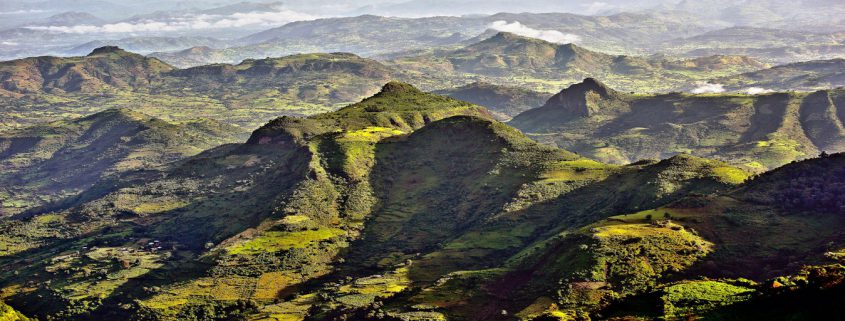
SEMIEN MOUNTAIN- THE ROOF OF AFRICA

The Simien Mountain massif is a broad plateau, cut off to the
north and west by an enormous single crag over 60 kilometers long. To
the south, the tableland slopes gently down to 2,200 meters, divided by
gorges 1,000 meters deep that can take more than two days to cross. Not
enough geological time has elapsed to smooth the contours of the crags
and buttresses of hardened basalt.–Simien Mountain National Park is
located at the northern edge of the central plateau of Ethiopia,
overlooking the Tekeze Gorges. It is part of the Simien Mountain Massif
in Northern Ethiopia, which lies at elevations between about 2,000m and
4,620m, taking in Ras Dashen, the highest peak in Ethiopia, which stands
adjacent to the park and the fourth highest in Africa.–The National
Park itself, with a core area of around 140km2 and one of the smallest
in Ethiopia, is located in the North Gondar zone of the Amhara National
Regional State. It is 130 km from Gondar, the capital of North Gondar
zone of Amhara region and about 882 km from Addis Ababa. It covers the
highlands, ranging up to an altitude of 3,000 m ( with the peak of
Bwahit Mountain at 4,430 m), and the lowlands, which lie at an average
altitude of below 2,000 m. the steep escarpments separating these two
significant landscapes were formed by volcanic activities and subsequent
erosion millions of years ago. They give the mountain scenery its
characteristic appearance, which is so spectacular for visitors today.
Located at the Gondar- Axsum axis, which are both cultural world
Heritage Sites on the so-called “Historic Route, you can reach the
National Park by passing Debark, a market town on the road to Axsum and
an important base for organizing trips to the National Park.–One of the
main justifications for establishing Simien Mountains National Park at
the time was the fact that the Simien area is the last stronghold of the
Walia ibex (capra walie). This animal is a type of wild goat and the
species, found only in the Simien, is the southernmost of its genus. The
Walia habitat covers the steep areas of the escarpment as well as the
grassy ledges where they need to feed and sun themselves in mornings and
evenings. The aftermath of war, poaching, and the destruction of
natural habitat has diminished the Walia population in the park to an
alarming extent. Meanwhile efforts to protect natural habitat have shown
first signs of progress. The number of animals

still living within and around the park boundaries has increased
again from an estimated total of 200-260 in 1994 (according to Swiss
research) to 400 today. The eastern and southeastern parts of the park
around the Bwahit — steep sloping rocks over 2,400 m — are particularly
good spots to see the Walia in its natural habitat, especially in the
morning up to ten o’clock and in the late afternoon. However, not only
the Walia makes Simien Mountains National Park a world heritage site.

The Simien fox or Ethiopian wolf (canis simiensis) is another highly
endangered species endemic to Ethiopia. Until recent time, there was
controversy as to the naming of this mammal. Today research has proved
that this animal is neither a jackal nor a fox. It is rather a wolf.
Hence, it is more correct to name it as Ethiopian wolf. The population
within and around the park is estimated to be as low as 30-40, while the
estimated total in the whole of Ethiopia does not exceed much more than
400 animals, which is an indication of the threatening situation for
the Ethiopian wolf. Its habitat continues to shrink as demand grows for
the Park’s high grass. This needs great attention for conservation.
Other animals in the park are much easier to observe. It is impossible
to enter the park without passing large groups of Gelada baboons
(Theropithecus gelada).The Gelada Baboon, sometimes referred to as the
bleeding heart Baboon, because of its bare bright red chest is the third
endemic mammal of this park. With a little bit of patience and luck you
might also see the Klipspringer (Oreotragus oreotragus), the Bush pig
(Potamochoerus porcus), the Bush Buck (Tragelaphus scriptus), the
colobus (colobus abyssinicus), grass rats, and other species. –More than
180 species of birds (6 endemic in the SMNP; one discovered recently in
1998) can be found in the Simien Mountains, the most famous being the
wattled Ibis , the Lammergeier, the thick-billed Raven and the Towny
eagle. The escarpments and lowland areas in particular are ideally
suited to observing various species of Birds. –Simien Mountains National
Park is the largest virtually natural habitat island in the Ethiopian
Highlands, and its surrounding cliffs and lowlands act as an ecological
barrier allowing the ecosystems to evolve almost independently.
–Therefore, in addition to this interesting fauna, the Simien also
boasts a wealth of fascinating flora. Generally, the vegetation in the
Simien area is characterized by three different altitudinal belts. These
are Afro alpine, Ericaceous and Afromontane forest belts. –The Afro
alpine steppe belt is above 3700 m above sea level. This altitudinal
belt is famous for the occurrence of the Giant Lobelia (Lobelia
rhynchopetalum) and is rounded off with a colorful patch work of red and
yellow flowers comprising the so called ” red hot poker” (Kniphofia
Foliosa and Kniphofia pumila). This is also the belt where silvery or
yellow straw – flowers called ” Everlastings ” (eg. Helichrysum
Citrospinum) which flower in the dry season are found.–Inside the
Ericaceous belt, between elevation of 3000 and 3700m., the most
interesting is the Erica-Hypericum communities composed of the Giant St.
Johns Worth (Hypericum Revolutum) and the Giant Heath (Erica Arborea).
Another remarkable plant native to the Simien and common at this
altitude is the Abyssinian Wild Rose (Rosa Abyssinica), whose
characteristic ivory white flowers can be admired especially during the
dry season. Still in the list of exceptionally large plants at this belt
is the Giant Sphere Thistle (Echnopes Longisetus).–The belt ranging
from 2000m-3000m is called the Afro Montane forest belt. More than about
100 species of trees can be found here and the bio diversity is
generally much higher than on the highland plateau.

Danakil Depression Looking into the bowel of the Earth

The Danakil Depression is a desert area in the Afar region of northeastern Ethiopia, north of the Great Rift Valley .

This is both the hottest region on earth averaged year round and one of the most geologically active.

This is the land of “Ardi” (Ardipithecus ramidus) and “Lucy” (Australopithecus afarensis)
– hominids which have been proposed as among our first putative
ancestors. In June 2010, the oldest direct evidence of stone tool
manufacture was found in this region and attributed to Australopithecus afarensis hominids dating back more than three million years ago.

Near the southern end of the Red Sea an immense, more or less
triangular, depression descends far below sea level – some points near
the ghost town of Dallol are nearly 116m below sea level). Known as the
Danakil/Dallol Depression, the northern part is extremely hot and dry
and an extension of the Great Rift Valley. In this seemingly
inhospitable area live the nomadic Afar people who number about 3
million.

The whole Afar Depression is a plate tectonic triple junction where
the spreading submarine ridges that formed the Red Sea and the Gulf of
Aden emerge on land and meet the East African Rift. The Afar Depression
is one of two places on Earth where a mid-ocean ridge can be studied on
land. At present, the Afar is slowly being pulled apart at a rate of
1-2cm per year. The floor of the Afar Depression is composed mostly of
basaltic lava. The Afar Depression and Triple Junction also mark the
location of a mantle plume, a great uprising of the earth’s mantle that
melts to yield basalt.

This place, which used to be part of the Red Sea, has kilometres of
salt deposits. In some places the salt deposits are about 5km (3 mi)
thick. Below many salt lakes are substantial sources of volcanic heat
which causes hot water to rise through layers of salt and deposit
anhydrites. Minerals also get dissolved and are deposited near the
springs, and form shapes very much reminiscent (but smaller than)
hornitos on basaltic lava flows. Sulphur, other minerals and possibly
Thermopylae bacteria cause spectacular colours. Acid pools and deposits
of salt, sulphur and other minerals at Dallol. This is a vast expanse of
blisteringly hot desert with lava flows and salt plains and lakes that
lie below sea level. Active and extinct volcanoes lie along a
south—north axis with the extremely salty Lake Afrera, at 120m below sea
level, kept alive by the many thermal springs feeding it.

Dallol — the lowest & hottest point on the planet

The Danakil Desert is located between the Ethiopian plateau and the
Red Sea. The salt plain near Dallol is the lowest part at 116 meters
below sea level. –In prehistoric times, the territory was in the form of
a gulf. According to geologists, this is a sea bed that emerged for a
brief moment in the history of the planet; the Afar depression will in
fact form a future ocean with the Red Sea and the Gulf of Aden. –This
geological anomaly means that the entire area is very unstable. There
are numerous active volcanoes and frequent earthquakes, /together with
secondary manifestations such as the stupendous colours of the salt
surfaces, caused by the geysers with their various different chlorides.
–This inhospitable territory is home to nomadic sheep-herding Afar
people. –This tribe has a strong sense of its own identity and enjoys a
notable degree of autonomy in its land. The Afar live from their
animals, agriculture and the sale of salt that they extract from the
salt lakes of the Danakil depression. The salt is loaded onto camels and
sold in the markets of the highlands.

Dallol offers an opportunity to see the first signs of a new ocean
basin forming. The Dallol volcano, the only volcanic crater below sea
level on land, has remained dormant since 1926, as the seabed it will
one day occupy gradually widens. South of Dallol, rectangular salt slabs
are cut and transported up into the highlands in a near endless
procession of camel caravans. The salt canyons south of Dallol Mountain
are some of the most impressive geological features in the area. It
looks like another planet because there are lots of colourful rocks in
each metre of terrain. It looks like something out of a science fiction
novel.

The town of Dallol, built from salt blocks and
which almost straddles the Eritrean border to the east of the Tigrayan
highlands, is officially listed as the hottest place on Earth, with an
average annual temperature of 35 degrees Celsius and hottest daily
temperatures topping 40°C year round. Much of this vast and practically
unpopulated region lies below the driest and most tectonically active
areas on the planet. The Danakil is an area of singular geological
fascination. A strange lunar landscape studded with active volcanoes
malodorous sulphur-caked hot springs. Solidified black lava flows. And
vast salt encrusted basins. It is some measure of the Danakil’s
geological activity that more than 30 active or dormant volcanoes
roughly one quarter of the total as listed by the Smithsonian instituted
global volcanism program. These volcanoes are all geological infants
having formed over the past million years and with a great many taking
their present shape within the last 10,000 years.

Erta Ale – the living Shield Volcano

Location: Lat. 13.6N, Long. 40.7E–Elevation:
2,011 feet (613 m)–Erta Ale is a very remote and rarely visited shield
volcano in the Afar region of East Africa. It is Ethiopia’s most active
volcano and it has been in a state of continuous eruption since 1967.
Daytime temperatures will likely be above 40 degrees Celcius and the
base of the volcano actually lies below sea level and it’s summit rises
up to 613 Meters. Erta Ale is known for it’s 2 pit craters which have
had active lava lakes in the past. –Erta Ale has undergone seven
eruption events in the past 125 years. Three of the early eruption
dates, 1873, 1903, and 1904 are uncertain. However, 1906, 1940, 1960,
and 1967 are well established events. Erta Ale has been erupting
continuously since 1967. –Two new studies on Erta Ale have recently been
published. Oppenheimer and Francis (1998) looked at the implications of
long-lived lava lakes. They believe that Erta Ale’s lava lake has been
active for at least the last 90 years (making it one of the longest
known historic eruptions). Large amounts of heat are released by the
volcano but the amount of lava that erupts is relatively small.
Oppenheimer and Francis speculated that a higher magma density (caused
by the cooling of the lava in the lake) inhibits eruptions. They
proposed that most of the magma accumulates in the underlying crust in
the form of dikes and sills. Since the Afar region is under extension,
conditions are favorable for the injection of dikes and sills. –Barrat
and others (1998) looked at the chemistry of the rocks at Erta Ale.
Rocks range in composition from basalt to rhyolite. Barrat and others
found that two mantle sources were tapped for the basalts: one similar
in composition to the source for mid-ocean ridge basalts (called MORB by
geochemists) and one similar in composition to the source for
ocean-island basalts (called OIB). Their data did not show a significant
contribution of sialic material from the continental crust.